Dockwray Footbridge plaque
Introduction
The photograph on this page of Dockwray Footbridge plaque by Ian Taylor as part of the Geograph project.
The Geograph project started in 2005 with the aim of publishing, organising and preserving representative images for every square kilometre of Great Britain, Ireland and the Isle of Man.

There are currently over 7.5m images from over 14,400 individuals and you can help contribute to the project by visiting https://www.geograph.org.uk
Dockwray Footbridge plaque
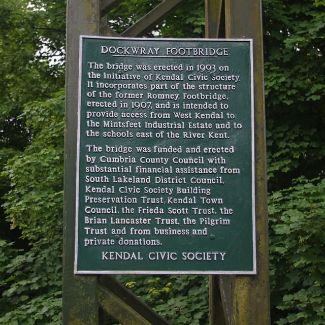
Image: © Ian Taylor Taken: 28 Jun 2017
The plaque states - DOCKWRAY FOOTBRIDGE The bridge was erected in 1993 on the initiative of Kendal Civic Society. It incorporates part of the structure of the former Romney Footbridge, erected in 1907, and is intended to provide access from West Kendal to the Mintsfeet Industrial Estate and to the schools east of the River Kent. The bridge was funded and erected by Cumbria County Council with substantial financial assistance from South Lakeland District Council, Kendal Civic Society Building Preservation Trust, Kendal Town Council, the Frieda Scott Trust, the Brian Lancaster Trust, the Pilgrim Trust and from business and private donations. KENDAL CIVIC SOCIETY See Image for a view of the bridge. Romney Footbridge had been replaced by a road bridge.
Images are licensed for reuse under creativecommons.org/licenses/by-sa/2.0
Image Location
Latitude
54.336017
Longitude
-2.744792