Flats, 150-160 Seacliff Road, Bangor (June 2017)
Introduction
The photograph on this page of Flats, 150-160 Seacliff Road, Bangor (June 2017) by Albert Bridge as part of the Geograph project.
The Geograph project started in 2005 with the aim of publishing, organising and preserving representative images for every square kilometre of Great Britain, Ireland and the Isle of Man.

There are currently over 7.5m images from over 14,400 individuals and you can help contribute to the project by visiting https://www.geograph.org.uk
Flats, 150-160 Seacliff Road, Bangor (June 2017)
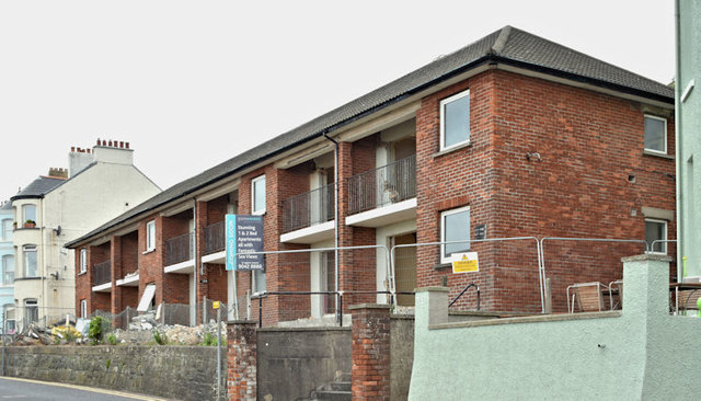
Image: © Albert Bridge Taken: 23 Jun 2017
A block of flats, built circa 1955, for the Bangor Provident Trust. They had been in the course of modernisation for sale but, given the special circumstances, it seems unlikely that the work will re-start soon. The following planning permission (14 December 2017) applies “LA06/2017/0805/F Refurbishment of 12 no. existing apartments including addition of front (sea view) dormers, rear dormers, removal of existing chimneys, change from hipped roof to gable peaks, red brick walls to be rendered (off-white render), new external ramp and existing balconies to be enclosed. (Amended proposal) 150 - 160 Seacliff Road Bangor Co.Down BT20 5HA”. See also Image For a later view, after redevelopment, see Image
Images are licensed for reuse under creativecommons.org/licenses/by-sa/2.0
Image Location
Latitude
54.668159
Longitude
-5.66061