Display Board at Millar Wood near Potter's Cross
Introduction
The photograph on this page of Display Board at Millar Wood near Potter's Cross by David Hillas as part of the Geograph project.
The Geograph project started in 2005 with the aim of publishing, organising and preserving representative images for every square kilometre of Great Britain, Ireland and the Isle of Man.

There are currently over 7.5m images from over 14,400 individuals and you can help contribute to the project by visiting https://www.geograph.org.uk
Display Board at Millar Wood near Potter's Cross
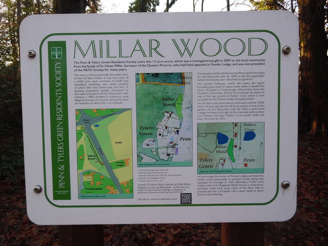
Image: © David Hillas Taken: 17 Jan 2017
Situated in Elm Road, HP10 8LQ, this display board was erected in 2016 by the Penn & Tylers Green Residents Society. It has the following wording: MILLAR WOOD The Penn & Tylers Green Residents Society owns this ½ acre wood, which was a most generous gift in 2007 to the local community from the family of Sir Oliver Millar, Surveyor of the Queen's pictures, who had lived opposite in Yonder Lodge, and was vice-president of the P & TG Society for many years. The first column says the following: The history of the wood tells the wider story of Penn & Tylers Green. It was once part of a 4,000 acre open common of heath and woodland stretching over seven parishes of which Tyler End Green was one "end". A growing population, greatly stimulated by the rapid emergence of the Wycombe chair industry c.1800, resulted in numerous small illegal enclosures of common land, particularly at roadsides, of which this is an example. Below this wording is the Millar Wood modern map. The middle column has a map of 1840 Chepping Wycombe Parish. The third column has the following wording: The wood straddles the Wycombe/Penn parish boundary. On the Wycombe side, by 1840, it was five separately owned enclosures, later described as "gardens". The ancient "holloway" which still marks the parish boundary, goes back to Saxon times when it divided the Saxon Hundred of Desborough (Wycombe) from the Hundred of Burnham (Penn). The holloway ran down to one of the two ponds at Potters Cross which is now occupied by the Thames Water pumping station. On the Penn side, there was no enclosure until the 1840s when ¼ acre was fenced off by an owner of one of the gardens on the Wycombe side. By 1863, a short-lived cottage had been built right by the road side with another one between the two Potters Cross ponds. Both had been removed by 1875. The third column then shows an 1863 Map of St Margaret's District. The wording continues as below: At some stage, the owner of Yonder Lodge purchased the whole wood, presumably to prevent houses being built opposite his frontage. In 1965, following a Public Local Inquiry held in St Margaret's Parish Room, a compulsory purchase order took away much of the Penn side to provide land for a footpath with a grass verge to allow future road-widening.
Images are licensed for reuse under creativecommons.org/licenses/by-sa/2.0
Image Location
Latitude
51.638693
Longitude
-0.69263