Milkbank House
Introduction
The photograph on this page of Milkbank House by Lynne Kirton as part of the Geograph project.
The Geograph project started in 2005 with the aim of publishing, organising and preserving representative images for every square kilometre of Great Britain, Ireland and the Isle of Man.

There are currently over 7.5m images from over 14,400 individuals and you can help contribute to the project by visiting https://www.geograph.org.uk
Milkbank House
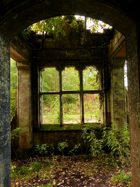
Image: © Lynne Kirton Taken: 9 Oct 2016
Designed in the Scottish Baronial style by architect Frank James Chambers Carruthers, Milkbank House was built in the late 1800s for the Bell-Irvine family and occupied for only around 60 years before being abandoned and left in decline. It is believed to have been requisitioned as a military hospital for servicemen during WW2, after which the owners either did not want to or could not afford to return to it. In some records it is listed as having been demolished, but in fact only the roof was removed, possibly for tax-related reasons. A once-beautiful mosaic floor and marble staircase can still be seen, along with an ornate fireplace. The house is easily accessible, as the Annandale Way long distance path passes right next to it, but caution should be exercised if entering the building (there are signs warning against doing so!) because of the possibility of falling masonry. Nearby are the Milkbank Kennels, also derelict, which housed the local hunt hounds. For a photo of the exterior, see Image A picture of the house in its heyday can be seen here http://www.slch.org.uk/images/milkbank_house.jpg It is still a magnificent building. Following the Annandale Way, one comes upon it quite suddenly, and covered as it is with creepers and other vegetation, it is not difficult to imagine that one has wandered on to the set of a Gothic horror film! Such a shame that it has been left to decay.
Images are licensed for reuse under creativecommons.org/licenses/by-sa/2.0
Image Location


Leaflet Map data © OpenStreetMap
Latitude
55.071616
Longitude
-3.348193