Roman Distance slab (?The Bridgeness Slab?)
Introduction
The photograph on this page of Roman Distance slab (?The Bridgeness Slab?) by Tom Sargent as part of the Geograph project.
The Geograph project started in 2005 with the aim of publishing, organising and preserving representative images for every square kilometre of Great Britain, Ireland and the Isle of Man.

There are currently over 7.5m images from over 14,400 individuals and you can help contribute to the project by visiting https://www.geograph.org.uk
Roman Distance slab (?The Bridgeness Slab?)
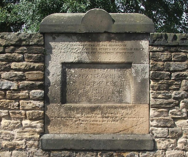
Image: © Tom Sargent Taken: 20 Aug 2007
On a wall near the spot where the original stone was found in Harbour Road is a copy of the inscription. It marks a portion of the Antonine wall built by the Second Legion. Mr Henry Cadell of the Grange, owner of the estate when it was excavated in 1869 offered the stone to The Society of Antiquaries of Scotland for display in the National Museum of Scotland in Edinburgh if they would provide a copy for display locally. In addition to the Latin inscription the original has sculpted panels. On the left is a victorious Roman cavalryman with his victims and on the right is a victory sacrifice in progress. There are photographs in “Roman Distance Slabs From the Antonine Wall” by Lawrence Keppie, Hunterian Museum, Glasgow. ISBN 0-904254-02-X The original description is in the proceedings of the Society of Antiquaries of Scotland Vol 8 (1868-69) page 109 - 113
Images are licensed for reuse under creativecommons.org/licenses/by-sa/2.0
Image Location
Latitude
56.016236
Longitude
-3.583696