Wainfleet Low Grounds between Old Fen Bank and Low Road: aerial 2017 (1)
Introduction
The photograph on this page of Wainfleet Low Grounds between Old Fen Bank and Low Road: aerial 2017 (1) by Chris as part of the Geograph project.
The Geograph project started in 2005 with the aim of publishing, organising and preserving representative images for every square kilometre of Great Britain, Ireland and the Isle of Man.

There are currently over 7.5m images from over 14,400 individuals and you can help contribute to the project by visiting https://www.geograph.org.uk
Wainfleet Low Grounds between Old Fen Bank and Low Road: aerial 2017 (1)
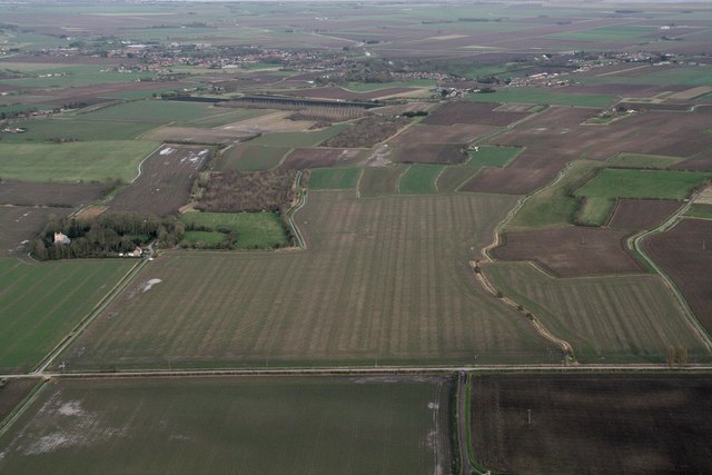
Image: © Chris Taken: 4 Mar 2017
Scald Gate right. Site of Medieval Town of Wainfleet: see http://www.pastscape.org.uk/hob.aspx?hob_id=355148&sort=2&rational=m&recordsperpage=10&maplat=53.10633271&maplong=0.19244582&mapisa=1000&mapist=os&mapilo=0.1924&mapila=53.1063&mapiloe=e&mapilan=n&mapios=TF467588&mapigrn=358850&mapigre=546750&mapipc=#aRt See also Image Most of the visible signs in this field were ploughed out in the 1960's. Old Fen Bank marks the eastern edge of the East Fen. East of it lie the Low Grounds (seen here). East of that is Low Road, the boundary with the Tofts. The geology, layout and water management of this area over the centuries are discussed in "Creating dry land in S.E. Lindsey (Lincolnshire, England) before AD 1550", "Rural landscapes between the East Fen and the Tofts in south-east Lincolnshire 1100–1550" and "The landscape development of the Tofts of south east Lincolnshire 1100 1650", all by Ian Simmons. He and others have made some of this material available as "Margins of the East Fen: Historic Landscape Evolution" - see https://www.dur.ac.uk/east-lincs-history
Images are licensed for reuse under creativecommons.org/licenses/by-sa/2.0
Image Location
Latitude
53.10361
Longitude
0.205069