King Edward III Manor House Rotherhithe
Introduction
The photograph on this page of King Edward III Manor House Rotherhithe by Marathon as part of the Geograph project.
The Geograph project started in 2005 with the aim of publishing, organising and preserving representative images for every square kilometre of Great Britain, Ireland and the Isle of Man.

There are currently over 7.5m images from over 14,400 individuals and you can help contribute to the project by visiting https://www.geograph.org.uk
King Edward III Manor House Rotherhithe
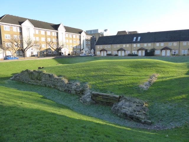
Image: © Marathon Taken: 18 Jan 2017
King Edward III reigned from 1327 to 1377 and he built a residence at Rotherhithe, the remains of which are seen here. It was constructed on a low-lying island surrounded by marshland. The buildings were surrounded by a moat on three sides and was originally open to the Thames on the north side. This allowed the King to arrive by boat and at high tide to moor up against the steps that led from the river to a gatehouse located in a tower. A likely reason for the place's existence was to house the King's falcons as Edward was a keen and expert falconer and the falcons would have flown over the river and the surrounding marshes. By the end of the 16th century the Thames waterfront had been pushed northwards by land reclamation and the old King's residence was completely surrounded by a moat. The Crown eventually sold the residence and it passed into private hands. In the 17th century the site became used as a pottery and in the 18th and 19th centuries warehouses were built across the site. In the 1970s the warehouses were demolished and archaeological investigation in the 1980s established that remains of Edward III's palace survived and the remains were preserved and made accessible to the public as can be seen here from Bermondsey Wall East. The remains of the north wall are on the left facing what would have been the moat. The base of the former tower is to the right with planks across the old entrance. An impression of what the palace would have originally looked like can be seen at http://www.geograph.org.uk/photo/5258851 and a full history is at http://www.historic-uk.com/HistoryMagazine/DestinationsUK/Edward-IIIs-Manor-House-Rotherhithe/
Images are licensed for reuse under creativecommons.org/licenses/by-sa/2.0
Image Location
Latitude
51.500086
Longitude
-0.059644