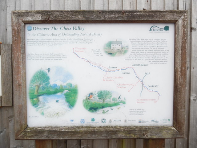
Noticeboard outside Chesham Station
Introduction
The photograph on this page of Noticeboard outside Chesham Station by David Hillas as part of the Geograph project.
The Geograph project started in 2005 with the aim of publishing, organising and preserving representative images for every square kilometre of Great Britain, Ireland and the Isle of Man.
There are currently over 7.5m images from over 14,400 individuals and you can help contribute to the project by visiting https://www.geograph.org.uk

Image: © David Hillas Taken: 1 Jul 2016
This noticeboard in Station Road HP5 1DH, has the heading "Discover The Chess Valley in the Chilterns Area of Outstanding Natural Beauty". It then has the following wording: "The CHESS VALLEY WALK follows the River Chess for 10 miles (16km) linking Chesham and Rickmansworth, passing through some of the most attractive countryside in the Chilterns Area of Outstanding Natural Beauty.You can also create your own circular walks, returning by public transport from the railway stations along the route". "The River Chess, one of several chalk streams in the Chilterns, is an important but vulnerable wildlife habitat. It supports some of our most threatened species, such as water vole, white-clawed crayfish and brown trout". The pictures show "The River Chess" (Left hand side), "Some of the wildlife you might see in and around the Chess and other chalk streams in the Chilterns" (Middle) and "Canon's Mill as it would have looked in the early 1900s" (Top right) The wording on the right says the following: "The Chess Valley Walk takes you on a journey into the fascinating past of this beautiful part of the Chilterns. Discover the site of a Roman farm-villa at Latimer, 13th century Chenies Manor House & Gardens, and historic Latimer House & parkland. Water meadows and ancient field systems can still be seen near Sarratt, as can the last working watercress beds on the Chess. Mills played an important role in the history of the valley and some of them can still be seen straddling the river. The site of old Flaunden village and its long derelict church, abandoned after the villagers relocated to the present site in the 1830s, is a symbol of the dramatic changes that have taken place in the valley over the centuries. The Chilterns logo can be seen at the top right hand corner of the noticeboard.

