Information board, Bready and Dunnalong
Introduction
The photograph on this page of Information board, Bready and Dunnalong by Kenneth Allen as part of the Geograph project.
The Geograph project started in 2005 with the aim of publishing, organising and preserving representative images for every square kilometre of Great Britain, Ireland and the Isle of Man.

There are currently over 7.5m images from over 14,400 individuals and you can help contribute to the project by visiting https://www.geograph.org.uk
Information board, Bready and Dunnalong
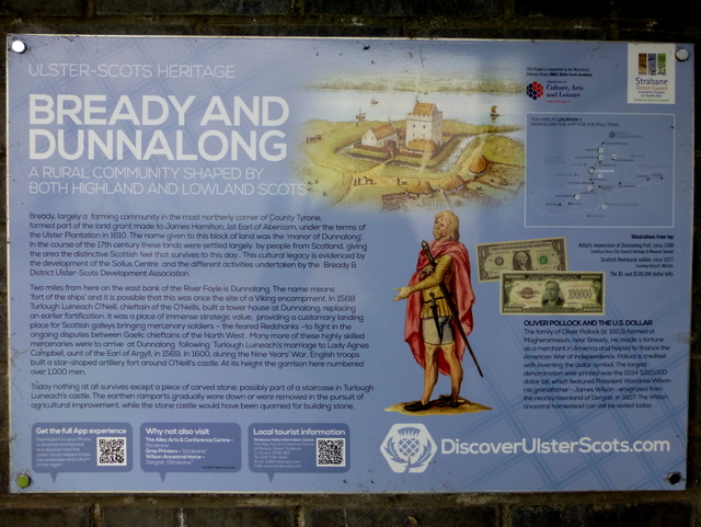
Image: © Kenneth Allen Taken: 17 Aug 2016
The following text is included in the description: BREADY AND DUNNALONG A rural community shaped by both Highland and Lowland Scots Bready, largely a farming community in the most northerly corner of County Tyrone, formed part of the land grant made to James Hamilton, 1st Earl of Abercorn, under the terms of the Ulster Plantation in 1610. The name given to this block of land was the 'manor of Dunnalong'. In the course of the 17th century these lands were settled largely by people from Scotland, giving the area the distinctive Scottish feel that survives to this day. This cultural legacy is evidenced by the development of the Sollus Centre and the different activities undertaken by the Bready & District Ulster-Scots Development Association. Two miles from here on the east bank of the River Foyle is Dunnalong. The name means 'fort of the ships' and it is possible that this was once the site of a Viking encampment. In 1568 Turlough Luineach O'Neill, chieftain of the O'Neills, built a tower house at Dunnalong, replacing an earlier fortification. It was a place of immense strategic value, providing a customary landing place for Scottish galleys bringing mercenary soldiers - the feared Redshanks -to fight in the ongoing disputes between Gaelic chieftains of the North West. Many more of these highly skilled mercenaries were to arrive at Dunnalong following Turlough Luineach's marriage to Lady Agnes Campbell, aunt of the Earl of Argyll, in 1569. In 1600, during the Nine Years' War, English troops built a star-shaped artillery fort around O'Neill's castle. At its height the garrison here numbered over 1,000 men. Today nothing at all survives except a piece of carved stone, possibly part of a staircase in Turlough Luineach's castle. The earthen ramparts gradually wore down or were removed in the pursuit of agricultural improvement while the stone castle would have been quarried for building stone. OLIVER POLLOCK AND THE U.S. DOLLAR The family of Oliver Pollock (d. 1823) farmed at Magheramason, near Bready. He made a fortune as a merchant in America and helped to finance the American War of Independence. Pollock is credited with inventing the dollar symbol. The largest denomination ever printed was the 1934 $100,000 bill, which featured President Woodrow Wilson. His grandfather-James Wilson- emigrated from the nearby townland of Dergalt in 1807 The Wilson ancestral homestead can still be visited today. Pictured here Image]
Images are licensed for reuse under creativecommons.org/licenses/by-sa/2.0
Image Location
Latitude
54.914941
Longitude
-7.419694