Upper adit for the Blairlogie copper mine
Introduction
The photograph on this page of Upper adit for the Blairlogie copper mine by Doug Lee as part of the Geograph project.
The Geograph project started in 2005 with the aim of publishing, organising and preserving representative images for every square kilometre of Great Britain, Ireland and the Isle of Man.

There are currently over 7.5m images from over 14,400 individuals and you can help contribute to the project by visiting https://www.geograph.org.uk
Upper adit for the Blairlogie copper mine
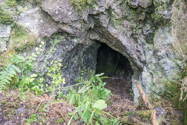
Image: © Doug Lee Taken: 19 Jun 2016
This is the adit for gaining access to the Blairlogie copper mine. It marks the highest point in the mine. The adit at the entrance to the mine is southeast of this point and further down the hill but has collapsed so that it is no longer possible to gain access to the mine at that point. The seam of copper ore was followed from that lower adit up to the one shown here. It is necessary to crawl in order to enter the mine but it opens up to standing height about four metres in. Some views of the immediate interior of the mine are shown in Image and Image The hillside around the adit is now very overgrown and locating the adit is difficult even when having visited the mine before. A view from the adit showing the vegetative cover can be seen in Image The mine was used in the early 18th century although there may have been some earlier activity. There are also several adits for mining trials elsewhere on Dumyat but this was the only active mine.
Images are licensed for reuse under creativecommons.org/licenses/by-sa/2.0
Image Location


Leaflet Map data © OpenStreetMap
Latitude
56.151821
Longitude
-3.88711