Myddelton House
Introduction
The photograph on this page of Myddelton House by Mike Quinn as part of the Geograph project.
The Geograph project started in 2005 with the aim of publishing, organising and preserving representative images for every square kilometre of Great Britain, Ireland and the Isle of Man.

There are currently over 7.5m images from over 14,400 individuals and you can help contribute to the project by visiting https://www.geograph.org.uk
Myddelton House
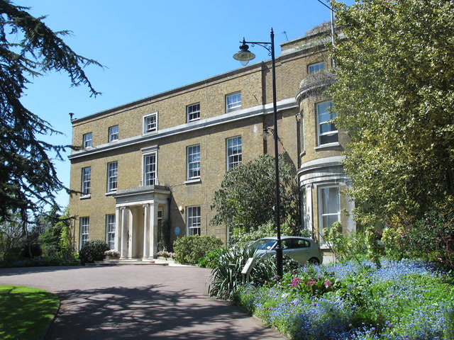
Image: © Mike Quinn Taken: 4 May 2016
Myddelton House was built on the site of an Elizabethan property in 1812-18 by Henry Bowles (who had married Anne Garnault – see Image ). It was named in honour of Sir Hugh Myddelton – see Image and is Grade II listed https://www.historicengland.org.uk/listing/the-list/list-entry/1000243 , along with the stable block to its north, a wall to the east of the gardens, the former Enfield Market Cross, an iron bridge over the former course of the New River, and the Lake Terrace https://www.historicengland.org.uk/listing/the-list/results?searchtype=nhle . The house eventually passed to EA Bowles (1865-1954) who became one of the great gardeners of the 20th century http://eabowlessociety.org.uk/history.htm . A section of the New River ran through the gardens from the early 17th C up to 1859 when the whole of the loop through what is now Whitewebbs Park was by-passed by the Docwra Aqueduct over Turkey Brook – see Image (photographed by David Kemp). The Bowles family continued to supply water to the section of the New River in their gardens until 1967 when the house and gardens were sold to the Lee Valley Regional Park Authority and the river was filled in with spoil from the building of the Victoria underground line. The gardens are now open – free - all year round (except Christmas and Boxing Days) from 10 am to 5 pm (or dusk if earlier); the Bowles Tea Room and Museum are open from 10 am to 4 pm. For further info see https://www.visitleevalley.org.uk/en/content/cms/nature/gardens-heritage/myddelton-house-gardens/#restoration-history .
Images are licensed for reuse under creativecommons.org/licenses/by-sa/2.0
Image Location
Latitude
51.674923
Longitude
-0.061003