View ENE across the Llanrug-Llanllyfni Platform
Introduction
The photograph on this page of View ENE across the Llanrug-Llanllyfni Platform by Eric Jones as part of the Geograph project.
The Geograph project started in 2005 with the aim of publishing, organising and preserving representative images for every square kilometre of Great Britain, Ireland and the Isle of Man.

There are currently over 7.5m images from over 14,400 individuals and you can help contribute to the project by visiting https://www.geograph.org.uk
View ENE across the Llanrug-Llanllyfni Platform
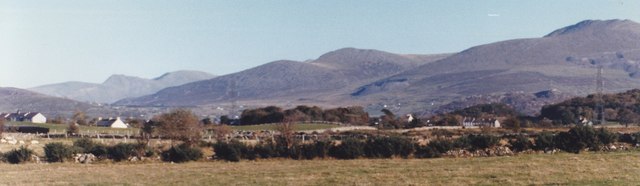
Image: © Eric Jones Taken: 21 Oct 1997
This is an uplifted marine-eroded platform on which much glacial debris was deposited during the Quaternary Ice Age to form drumlins. On its landward side are low rocky hills of Pre-Cambrian rocks against which the mountains of Snowdonia (in the background) were buckled by orogenic processes.
Images are licensed for reuse under creativecommons.org/licenses/by-sa/2.0
Image Location
Latitude
53.143101
Longitude
-4.193703