Churchill Square, Brighton
Introduction
The photograph on this page of Churchill Square, Brighton by Simon Carey as part of the Geograph project.
The Geograph project started in 2005 with the aim of publishing, organising and preserving representative images for every square kilometre of Great Britain, Ireland and the Isle of Man.

There are currently over 7.5m images from over 14,400 individuals and you can help contribute to the project by visiting https://www.geograph.org.uk
Churchill Square, Brighton
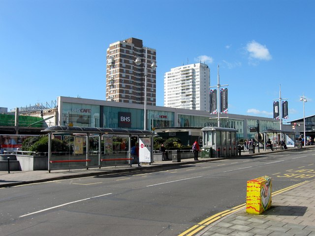
Image: © Simon Carey Taken: 25 Mar 2016
The main shopping centre of Brighton occupies a large site to the south of Western Road. The first complex was built in the 1960s and required the demolition of a run down area of town. Work commenced in 1965 and the first shop opened in 1967 though many of the units were not filled until 1968 when the centre was officially opened. It then consisted of an open precinct built around a large rectangular area of buildings that included a couple of office blocks. To the rear was a small square with the rest of precinct located to the south. In 1971-72 this part of the precinct was extended downwards by two levels. On the northern side adjacent to Western Road a large open area was constructed along with a circular building containing a cafe on the eastern side. This area formerly contained numbers 1-28 Western Road which had remained standing whilst the centre was being built to its rear. Initially popular the centre began ageing badly during the 1980s. It had been the last major open precinct built in the UK with trends pointing towards indoor malls from the early 1970s onwards. As such the precinct became an unpleasant place to shop open to the elements particularly the wind. The open nature of the shopping centre meant the lower levels soon began to attract the less salubrious creatures of the night thus beginning a spiral of businesses moving out and the centre unable to attract replacements causing more to vacate their premises. When Tesco’s left the lower level at the end of the 1980s there were calls to modernise the centre. Deals were finally agreed with the landowners, Standard Life, in the mid 1990s with work beginning in 1996. The new indoor mall opened in 1998 attracting many businesses though initially to the detriment of Western Road which lost a number of flagship stores, particularly Debenhams from its western end. In recent years the 1998 facade has undergone refurbishment gaining a nice new glass frontage. ROADS LOST TO DEVELOPMENT Upper Russell Street - Ran south from Western Road then turned west to the junction of Russell Square and Clarence Street. A tiny section survives outside the public houses, Crown’s and western Front. Grenville Place - The most contentious removal due to the early 19th century cobbled fronted terrace. Ran from Upper Russell Street to Clarence Street, its line roughly followed by the current shop fronts. Clarence Street - A narrow street heading south from Western Road to Russell Square. The Prince of Wales public house was originally located at the junction with Clarence Square and still survives on the western side of the precinct. Russell Street - Headed south from Upper Russell Street to King’s Road. It’s southern part now lies beneath the Brighton centre. Artillery Street - Ran south from Upper Russell Street to Cannon Street. Cannon Street - Ran south from Upper Russell Street then turned east to Russell Street. Now lies beneath the multi storey car park. Milton Place - Cul de sac off Great Russell Street cleared in 1935. Blucher Place - To the south of milton Place and cleared at the same time. Kents Court - Cul de sac off Russell Street. Russell Place - A cul de sac originally ran east from Russell Street to St Paul’s Church. The road name has been kept but now runs north from Russell Road. Cannon Lane - A cul de sac running south of Great Russell Street that mostly lies beneath Chartwell Court. Old Images Number 1 Western Road, 1966 - http://regencysociety-jamesgray.com/volume19/source/jg_19_158.html Numbers 3-10 Western Road, 1967 - http://regencysociety-jamesgray.com/volume19/source/jg_19_159.html Numbers 22-25 Western Road, 1967 - http://regencysociety-jamesgray.com/volume19/source/jg_19_164.html Aerial view of the cleared site with the rear of 1-28 Western Road still standing, 1966 - http://regencysociety-jamesgray.com/volume29/source/jg_29_204.htm Aerial view of Churchill Square, 1968 - http://regencysociety-jamesgray.com/volume29/source/jg_29_210.htm Similar view from 1980 - https://s-media-cache-ak0.pinimg.com/736x/9d/55/23/9d5523cf961d375d377a0d9ce53a1b73.jpg Churchill Square, 1985 (This section is now inside the mall but still retains the turn located on the eastern side. I briefly worked for HMV at this site at the end of the decade) - https://s-media-cache-ak0.pinimg.com/736x/55/2a/c7/552ac77e51281f8db545f29720ca652f.jpg
Images are licensed for reuse under creativecommons.org/licenses/by-sa/2.0
Image Location
Latitude
50.823406
Longitude
-0.14562