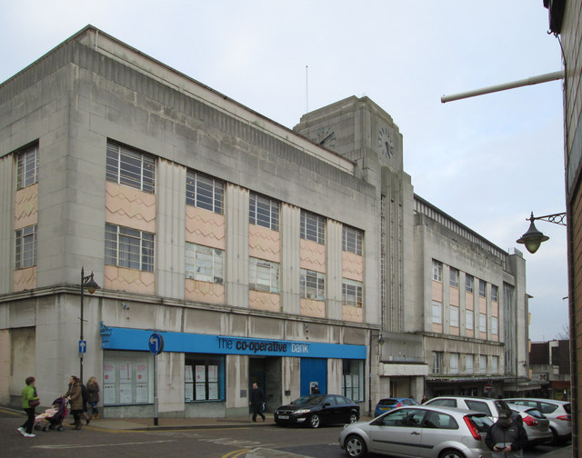
Mansfield - The Co-op Bank and Beales Department Store
Introduction
The photograph on this page of Mansfield - The Co-op Bank and Beales Department Store by Dave Bevis as part of the Geograph project.
The Geograph project started in 2005 with the aim of publishing, organising and preserving representative images for every square kilometre of Great Britain, Ireland and the Isle of Man.
There are currently over 7.5m images from over 14,400 individuals and you can help contribute to the project by visiting https://www.geograph.org.uk

Image: © Dave Bevis Taken: 12 Feb 2016
This building on Queen Street currently houses the Cooperative Bank and Beales Department Store. The main entrances to Beales are on the neighbouring Stockwell Gate. A brief history of the Mansfield Co-operative Society follows below. 1864: The Mansfield Co-operative Society is formed. 1914: By this date the Co-op was operated by the Mansfield & Sutton Co-operative, according to the war memorial plaque now sited in the Queen Street premises. 1918: The store on Stockwell Gate was destroyed in a fire. 1922: The new and enlarged Mansfield & Sutton Co-operative store, Stockwell Gate, opens on the site of that destroyed by fire in 1918. 1938: The Queen Street building was officially opened. 1970: The Co-operative Societies of Mansfield & Sutton, Pleasley, Pleasley Hill, and Clowne, were merged. 1983: The Greater Nottingham and the Mansfield and Worksop Co-operative Societies agreed to merge. 1984: A Co-op Superstore was opened on the site of the old Portland Wharf, Station Street. 2006: The Greater Nottingham Coop transferred its department store businesses (including the one in Mansfield) to the Anglia Co-operative Society and the stores were rebranded as "Westgate" (not to be confused with the nearby street name in Mansfield). 2011: The Anglia Society sold the business of its 19 Westgate Department Stores, including the one in Mansfield, to Beales. Most of the above information is provided at http://www.ourmansfieldandarea.org.uk/page_id__501_path__0p2p19p.aspx , but other information has been provided by http://www.iwm.org.uk/memorials/item/memorial/27083 , http://www.picturethepast.org.uk/frontend.php?keywords=Ref_No_increment;EQUALS;NCCW001831&pos=9&action=zoom&id=50810 , http://www.picturethepast.org.uk/frontend.php?keywords=Ref_No_increment;EQUALS;NCCW002413&pos=4&action=zoom&id=51387 , and http://www.chad.co.uk/news/local/co-op-sale-boost-for-historic-outlet-1-3264920 .

