
Tile map of North Eastern Railway, Tynemouth Metro Station
Introduction
The photograph on this page of Tile map of North Eastern Railway, Tynemouth Metro Station by Andrew Curtis as part of the Geograph project.
The Geograph project started in 2005 with the aim of publishing, organising and preserving representative images for every square kilometre of Great Britain, Ireland and the Isle of Man.

There are currently over 7.5m images from over 14,400 individuals and you can help contribute to the project by visiting https://www.geograph.org.uk
Tile map of North Eastern Railway, Tynemouth Metro Station
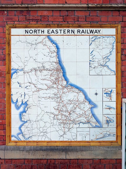
Image: © Andrew Curtis Taken: 20 Nov 2015
North Eastern Railway tiled system map was at one time a common feature in the company’s principal stations. The polychrome tile map of the NER network dates from about 1903 when the company was at its peak. The map shows how, over much of its area, the NER was virtually a monopoly with competition from other companies confined to the periphery. It also includes show some lines that were planned but not built. The map was manufactured by Craven, Dunnill & Co – a firm of encaustic and decorative tile manufacturers founded nearly 130 years ago. The company still exists and trades from its original premises now called Jackfield Tile Museum in Ironbridge, Shropshire Image When they were originally made, the design for each tile was etched on to copper which was then used to print a transfer. This was then carefully placed on to the tile – a very skilful task. Where any correction or hand finishing was required, that was then done before the tiles were glazed - always by hand - and fired in a kiln. There were 23 NER Tile Maps in all, erected at the following stations: Hexham, Durham, Morpeth, South Shields, Tynemouth, Normanton, Leeds City South, Whitby, Scarborough Image, Beverley Image, Bridlington, Saltburn, Hull, Selby, York, Darlington, Middlesbrough. Goole, Newcastle Central, Alnmouth, West Hartlepool, London Kings Cross and Tyne Dock. Only a few have survived although replicas are now available. https://sites.google.com/site/northeasternrailwayassoc/research-information/ner-tile-maps
Images are licensed for reuse under creativecommons.org/licenses/by-sa/2.0
Image Location

Latitude
55.017535
Longitude
-1.428672