Bank and Town Hall
Introduction
The photograph on this page of Bank and Town Hall by Bob Harvey as part of the Geograph project.
The Geograph project started in 2005 with the aim of publishing, organising and preserving representative images for every square kilometre of Great Britain, Ireland and the Isle of Man.

There are currently over 7.5m images from over 14,400 individuals and you can help contribute to the project by visiting https://www.geograph.org.uk
Bank and Town Hall
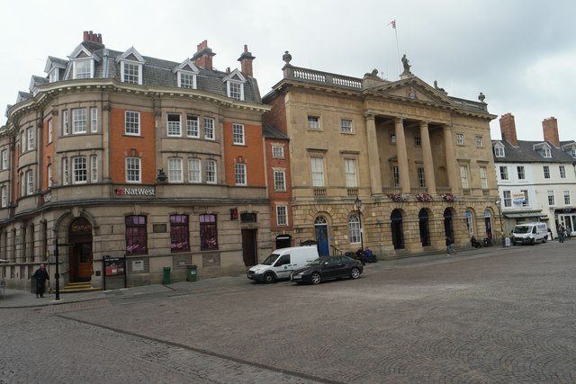
Image: © Bob Harvey Taken: 15 Oct 2015
Dating from 1902 the National Westminster bank building is a grade II listed building. An earlier Bank, Samuel Smith's Bank, stood here before the rebuilding, and before that the house of Alderman Clay, which was destroyed in the siege during the civil war. Smith's bank was part of a group called Smith, Payne & Smiths which merged in 1902 with the Union Bank of London to form the Union of London & Smiths Bank. By 1918 that had become the National Provincial & Union bank, and so remained until the formation of Nat West in 1968 See https://www.historicengland.org.uk/listing/the-list/list-entry/1231081 and http://heritagearchives.rbs.com/companies/list/union-of-london-and-smiths-bank-ltd.html for details. The Town Hall, built above the Butter Market dates from 1774 and was designed by John Carr of York. It is, deservedly, a grade I listed building. The town hall functions are still located upstairs as they ever were, although the market hall below was cleared in the late 20th century to make way for boutique shopping, as with the Victorian Butter Market Hall behind. The group of white buildings beyond are also grade II listed 18th century buildings. See https://www.historicengland.org.uk/listing/the-list/list-entry/1196276 See https://www.historicengland.org.uk/listing/the-list/list-entry/1196430 for details.
Images are licensed for reuse under creativecommons.org/licenses/by-sa/2.0
Image Location
Latitude
53.076195
Longitude
-0.809981