Change in Walworth Road, Walworth, London
Introduction
The photograph on this page of Change in Walworth Road, Walworth, London by Robin Stott as part of the Geograph project.
The Geograph project started in 2005 with the aim of publishing, organising and preserving representative images for every square kilometre of Great Britain, Ireland and the Isle of Man.

There are currently over 7.5m images from over 14,400 individuals and you can help contribute to the project by visiting https://www.geograph.org.uk
Change in Walworth Road, Walworth, London
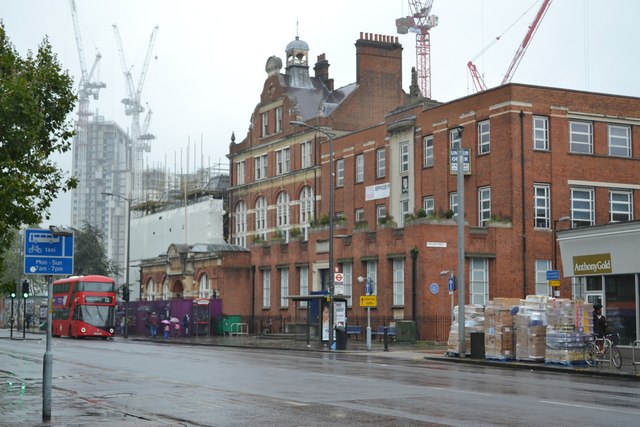
Image: © Robin Stott Taken: 21 Sep 2015
From right to left: the former Walworth Clinic seeking new uses; Newington Library with the big gable and chimney, being refurbished in association with Walworth Town Hall, under plastic during rebuilding. In the distance, the apartment blocks going up at 'Elephant Park' on the site of the demolished Heygate estate. The upper floors of the great high-rise slabs of flats of the Heygate are visible in Stephen McKay's photo from 2008 Image Another view is Image; more information below. The Walworth Town Hall building suffered extensive damage during the fire in March 2013; the adjacent Newington Library was also affected. Southwark Council are committed to respecting this historic building and developing new facilities for the community. Following the fire, cabinet agreed a high-level vision for the future of the rebuilt building as a new, world class civic centre for Walworth. It will include: • An enhanced Newington Library space. • A space for the display of the Cuming collection and Southwark museum • A flexible space that could be used for a variety of purposes including community and civic events, exhibitions and performances • Facilities for marriage, civil partnership and citizenship ceremonies undertaken by the Southwark registrar’s service See http://www.southwark.gov.uk/wth History of Walworth Town Hall (from the site hoarding) London’s second oldest Vestry Hall was designed by architect Henry Jarvis in an eclectic gothic style and built in 1864-66. At that time offices in the building included those for the Surveyor of Sewers and the Inspector of Nuisances!* In 1902 it was extended to include the east wing as the metropolitan boroughs came into power and their area of responsibility grew. Further alterations were made in the late 1940s and the 1960s. The building ceased to be the Southwark Town Hall in 1965 and was used for council offices and the charities commission. *’Nuisances’ was a euphemism for waste of any kind deposited in public places such as the highway. It could be offal and bones from private slaughterhouses; it could be excrement, animal or human; it could refer to urination in public.
Images are licensed for reuse under creativecommons.org/licenses/by-sa/2.0
Image Location
Latitude
51.490718
Longitude
-0.097063