Looking down the line at Medstead & Four Marks station
Introduction
The photograph on this page of Looking down the line at Medstead & Four Marks station by Marathon as part of the Geograph project.
The Geograph project started in 2005 with the aim of publishing, organising and preserving representative images for every square kilometre of Great Britain, Ireland and the Isle of Man.

There are currently over 7.5m images from over 14,400 individuals and you can help contribute to the project by visiting https://www.geograph.org.uk
Looking down the line at Medstead & Four Marks station
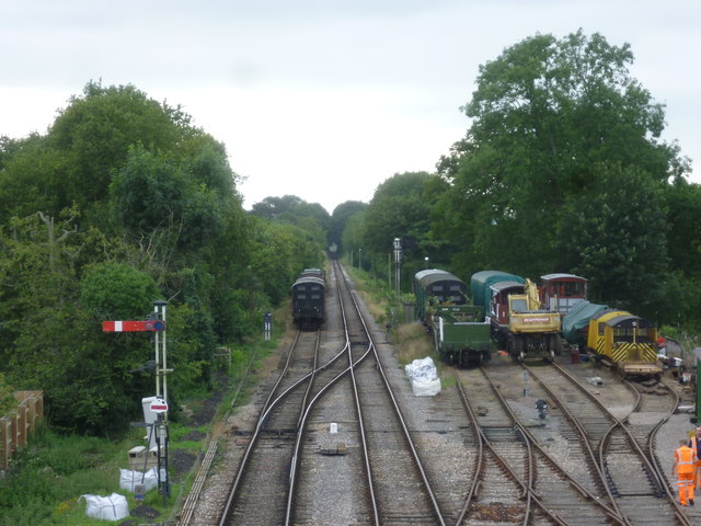
Image: © Marathon Taken: 5 Sep 2015
The Alton, Alresford & Winchester Railway changed its name to the Mid-Hants Railway in early 1865 and opened in October of that year. There were scheduled through trains up until 1937 when the line from Waterloo as far as Alton was electrified. The Mid-Hants line beyond then became much more branch line in character. There was a steady decline in usage after Nationalisation in 1948, although the introduction of modern diesel multiple units in 1957 with a much-improved frequency of service gave an increase in business for a few years. However, the advent of the Beeching era in the 1960s started the closure rumours and the line between Alton and Winchester closed in February 1973. The idea of preserving the line had started before closure and a preservation society had been formed. It was intended originally to save the whole line between Alton and Winchester but this was pared down to the present railway. The first train to Ropley ran on 30th April 1977, and the line from there to Medstead & Four Marks was reopened on 28th May 1983. Alton and connection with the national rail network was reached on 25th May 1985. Medstead & Four Marks station was originally known as Medstead from the village a mile to the north. However, as the settlement of Four Marks grew up along the main road after the First World War and this is now bigger than Medstead, the name was changed to include both. The station is the highest in southern England at over 630 feet above sea level. It is preserved as a typical country station of the 1940s. The footbridge, from where this photograph was taken, came from Cowes on the Isle of Wight. The original signal box was demolished and the present one came from Wilton, near Salisbury. The booking office has been restored and fitted out to look as though the occupant left only a few minutes before. Looking down the line towards Ropley, the trees in the distance give a tunnel effect.
Images are licensed for reuse under creativecommons.org/licenses/by-sa/2.0
Image Location
Latitude
51.112401
Longitude
-1.048539