Running Man: Panel 7
Introduction
The photograph on this page of Running Man: Panel 7 by Gerald England as part of the Geograph project.
The Geograph project started in 2005 with the aim of publishing, organising and preserving representative images for every square kilometre of Great Britain, Ireland and the Isle of Man.

There are currently over 7.5m images from over 14,400 individuals and you can help contribute to the project by visiting https://www.geograph.org.uk
Running Man: Panel 7
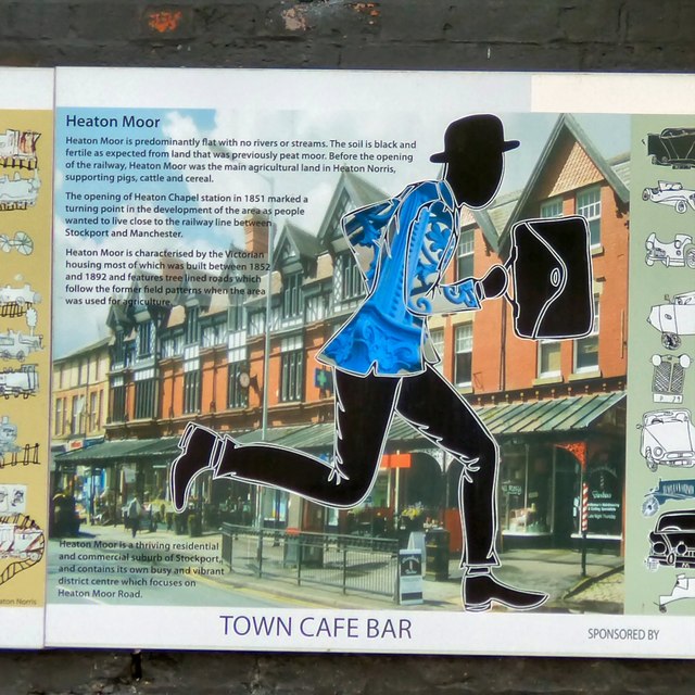
Image: © Gerald England Taken: 25 Jun 2015
Panel 7 was sponsored by Town Cafe Bar and informs us: Heaton Moor is predominantly flat with no rivers or streams. The soil is black and fertile as expected from land that was previously peat moor. Before the opening of the railway, Heaton Moor was the main agricultural land in Heaton Norris, supporting pigs, cattle and cereal. The opening of Heaton Chapel station in 1851 marked a turning point in the development of the area as people wanted to live close to the railway line between Stockport and Manchester. Heaton Moor is characterised by the Victorian housing most of which was built between 1852 and 1892 and features tree lined roads which follow the former field patterns when the area was used for agriculture. Heaton Moor is a thriving residential and commercial suburb of Stockport and contains its own busy and vibrant district centre which focuses on Heaton Moor Road.
Images are licensed for reuse under creativecommons.org/licenses/by-sa/2.0
Image Location
Latitude
53.425737
Longitude
-2.179494