Whiteford Temple
Introduction
The photograph on this page of Whiteford Temple by Des Blenkinsopp as part of the Geograph project.
The Geograph project started in 2005 with the aim of publishing, organising and preserving representative images for every square kilometre of Great Britain, Ireland and the Isle of Man.

There are currently over 7.5m images from over 14,400 individuals and you can help contribute to the project by visiting https://www.geograph.org.uk
Whiteford Temple
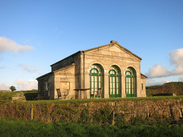
Image: © Des Blenkinsopp Taken: 28 Apr 2015
Called a "temple" in the fanciful style of the day, this was a landscape enhancing folly built in 1799 on the estate of a now vanished country house. When the house was in its prime there are accounts of splendid parties being held here, but hard times were round the corner and it ended up as a cowshed until the Duchy of Cornwall gave it to the Landmark Trust for conversion into a luxury gite. http://www.landmarktrust.org.uk/search-and-book/properties/whiteford-temple-13131/?ZJjYEWg8T5Uilneb2kJmmS/wLBbpScPDWPkQYkUs2jKimMkl8JroVkZ1LNSZZVkRveNfLERN7+qKxC5H0Txpg+94JstcJT4OYR+qzXFaBeiK3pgE8nRW4rQmYQ1HNQls7iAyiHVIUS2gt8DXY4Y1rvIpG77WF0hM
Images are licensed for reuse under creativecommons.org/licenses/by-sa/2.0
Image Location
Latitude
50.540734
Longitude
-4.324866