Eglwys Mynydd Seion, Abergele
Introduction
The photograph on this page of Eglwys Mynydd Seion, Abergele by David Dixon as part of the Geograph project.
The Geograph project started in 2005 with the aim of publishing, organising and preserving representative images for every square kilometre of Great Britain, Ireland and the Isle of Man.

There are currently over 7.5m images from over 14,400 individuals and you can help contribute to the project by visiting https://www.geograph.org.uk
Eglwys Mynydd Seion, Abergele
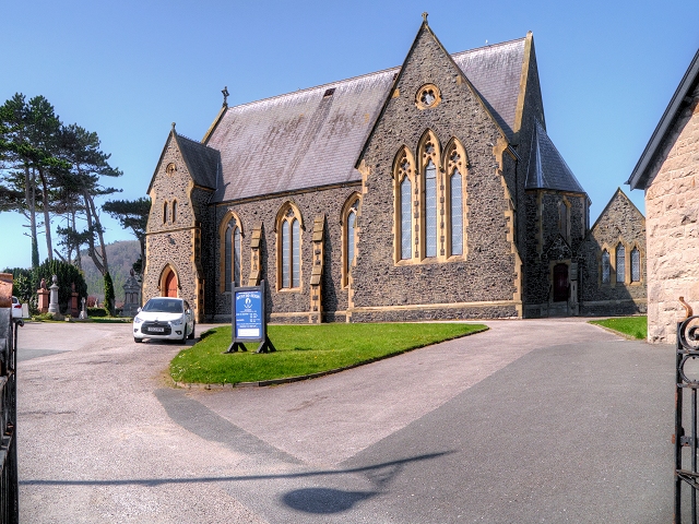
Image: © David Dixon Taken: 21 Apr 2015
The Calvinistic Methodist chapel was rebuilt in 1867-8 in early Gothic style to replace the earlier smaller chapel of 1791 close to the same site. The present building is set on an elevated platform, almost opposite the junction with High Street. This chapel now serves the Welsh Presbyterian community. The church is built of rock-faced black basaltic stone, probably from Penmaenmawr, with sharply contrasting Batholithic limestone dressings, and a slate roof. The east side, facing Chapel Street, has three 2-light windows beyond the stair wing, separated by buttresses, and gabled transepts at the north end, having triple tall lancets with quatrefoil heads and a gable oculus. The north end terminates in a polygonal apse with a hipped roof and, almost detached, a vestry set at right angles under a separate roof. The church is grade II-listed (Cadw Building ID: 18662 http://www.britishlistedbuildings.co.uk/wa-18662-eglwys-mynydd-seion-abergele#.VTqvqmd0x_s British Listed Buildings) as “a distinctive and well-preserved chapel by a notable chapel architect”.
Images are licensed for reuse under creativecommons.org/licenses/by-sa/2.0
Image Location
Latitude
53.283047
Longitude
-3.583276