Stanley Road: a visit to their old school
Introduction
The photograph on this page of Stanley Road: a visit to their old school by John Sutton as part of the Geograph project.
The Geograph project started in 2005 with the aim of publishing, organising and preserving representative images for every square kilometre of Great Britain, Ireland and the Isle of Man.

There are currently over 7.5m images from over 14,400 individuals and you can help contribute to the project by visiting https://www.geograph.org.uk
Stanley Road: a visit to their old school
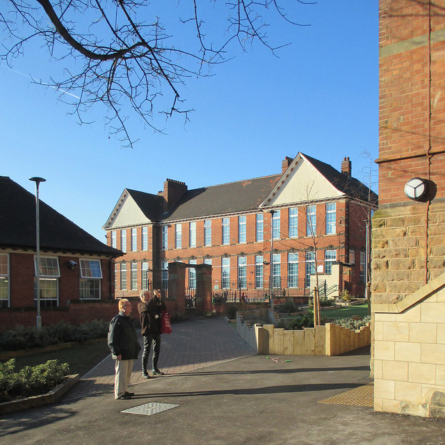
Image: © John Sutton Taken: 9 Feb 2015
An old boy of High Pavement Grammar School takes a picture of the entrance he went through every school day of his life sixty years before. See Image] for his view. In grammar-school days the gabled building in the background was known as T Block. Like the infant school to the left and the main building to the right, it is part of the enlarged primary school. Forest Fields Primary is the fourth school – after High Pavement and Forest Fields Grammar Schools and Claremont Secondary – to occupy the Grade II listed building on Stanley Road, which was refurbished at a cost of £6.5m in 2013-14. This picture was taken during a tour of the building by Old Paviors (and two Old Forestians), some of whose memories of the school dated back to the late 1930s. Image] shows the building in 2003. Image] and Image] show building work in progress in 2013. For the Grade II listing, see http://www.britishlistedbuildings.co.uk/en-458870-clarendon-college-berridge-centre- .
Images are licensed for reuse under creativecommons.org/licenses/by-sa/2.0
Image Location
Latitude
52.970544
Longitude
-1.166543