Cow Lane/King's Marina Vicinity, Newark, Notts.
Introduction
The photograph on this page of Cow Lane/King's Marina Vicinity, Newark, Notts. by David Hallam-Jones as part of the Geograph project.
The Geograph project started in 2005 with the aim of publishing, organising and preserving representative images for every square kilometre of Great Britain, Ireland and the Isle of Man.

There are currently over 7.5m images from over 14,400 individuals and you can help contribute to the project by visiting https://www.geograph.org.uk
Cow Lane/King's Marina Vicinity, Newark, Notts.
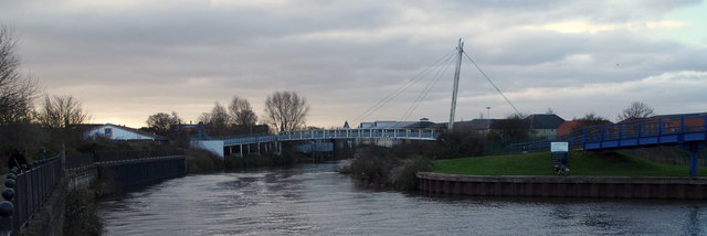
Image: © David Hallam-Jones Taken: 1 Feb 2015
The Cow Lane footbridge ahead provides a link between, Cow Lane on the left (a lane off Northgate, the B6166) and The King's Marina on the north bank of the River Trent (the Mather Road area of Newark). The riverside walk - ahead - ceases when it reaches the footbridge compelling pedestrians to cross to the north side of the river or to return along this footpath until reaching Trent Lane (off Northgate). If turning back, one alternative route that also provides access to the B6166 is a footpath to right - within 200 yards of where the photographer was standing - that runs parallel with the former Warkwick Maltings, and immediately afterwards, the former Warwick (Northgate) Brewery buildings.
Images are licensed for reuse under creativecommons.org/licenses/by-sa/2.0
Image Location
Latitude
53.081836
Longitude
-0.807735