Old Penwortham Bridge
Introduction
The photograph on this page of Old Penwortham Bridge by David Dixon as part of the Geograph project.
The Geograph project started in 2005 with the aim of publishing, organising and preserving representative images for every square kilometre of Great Britain, Ireland and the Isle of Man.

There are currently over 7.5m images from over 14,400 individuals and you can help contribute to the project by visiting https://www.geograph.org.uk
Old Penwortham Bridge
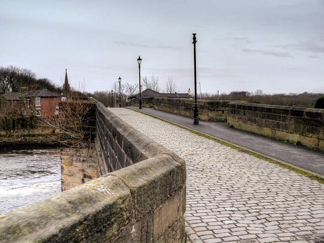
Image: © David Dixon Taken: 14 Jan 2015
The “Old” Penwortham Bridge is a Georgian masonry former road bridge spanning the River Ribble connecting Broadgate to Penwortham and now used for foot traffic. It was built in 1759 to replace an earlier bridge which was constructed here in 1755 but had collapsed just one year after completion. The bridge's deck is 5½ metres wide, has a cobbled surface and solid parapets. There is an asphalt footway on the downstream side. A cast iron lamp standard is located in a projection on the eastern side. The bridge originally carried the main road from Preston to Leyland, Southport and Liverpool. It has been superseded in recent years by the modern A59 bridge half a mile downstream, Image], (http://www.engineering-timelines.com/scripts/engineeringItem.asp?id=649 Engineering Timelines) Old Penwortham Bridge is a grade II listed building (English Heritage Building ID: 357988 http://www.britishlistedbuildings.co.uk/en-357988-old-penwortham-bridge-lancashire British Listed Buildings)
Images are licensed for reuse under creativecommons.org/licenses/by-sa/2.0
Image Location
Latitude
53.748941
Longitude
-2.713894