Hangars at north east corner of former RAF Yatesbury air base
Introduction
The photograph on this page of Hangars at north east corner of former RAF Yatesbury air base by Vieve Forward as part of the Geograph project.
The Geograph project started in 2005 with the aim of publishing, organising and preserving representative images for every square kilometre of Great Britain, Ireland and the Isle of Man.

There are currently over 7.5m images from over 14,400 individuals and you can help contribute to the project by visiting https://www.geograph.org.uk
Hangars at north east corner of former RAF Yatesbury air base
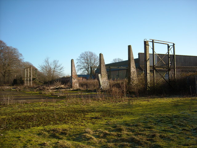
Image: © Vieve Forward Taken: 13 Dec 2014
In the foreground are the remains of south side of a Grade II* listed WW1/WW2 hangar at the former RAF Yatesbury West Camp air base. http://www.britishlistedbuildings.co.uk/en-316298-former-hangar-at-north-east-corner-of-fo http://www.pastscape.org.uk/hob.aspx?hob_id=1308172&sort=4&search=all&criteria=hangar&rational=q&recordsperpage=10&p=28&move=n&nor=311&recfc=0 This hangar, built in 1916 for the servicing and repair of aircraft, was timber-framed with corrugated iron cladding and a curved and boarded roof. Unfortunately, due to neglect, very little of it remains. For comparison, see http://klempner69.smugmug.com/Military/Derelict-Buildings/RAF-YatesburyWiltshire/i-QHrkDtw/A which shows its condition in 2005. See also Image Behind it can be seen Hangar 45, a restored and converted WW2 hangar, see Image] .
Images are licensed for reuse under creativecommons.org/licenses/by-sa/2.0
Image Location
Latitude
51.441656
Longitude
-1.919523