Carre Street Vicinity, Sleaford, Lincs.
Introduction
The photograph on this page of Carre Street Vicinity, Sleaford, Lincs. by David Hallam-Jones as part of the Geograph project.
The Geograph project started in 2005 with the aim of publishing, organising and preserving representative images for every square kilometre of Great Britain, Ireland and the Isle of Man.

There are currently over 7.5m images from over 14,400 individuals and you can help contribute to the project by visiting https://www.geograph.org.uk
Carre Street Vicinity, Sleaford, Lincs.
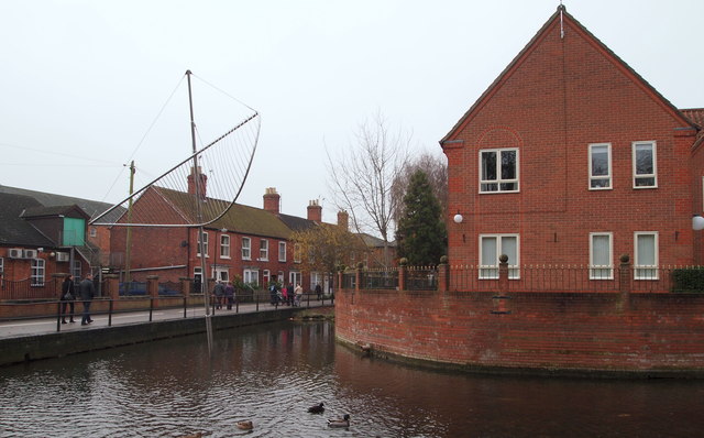
Image: © David Hallam-Jones Taken: 29 Nov 2014
On the left is the gable end of one of the Berkeley Court apartment blocks. These were developed in 1980 and they occupy the former Lee & Green mineral water factory site. The factory operated between 1880-1940s. The metal sculpture seen here, where the dry, non-navigable spur heads towards the former Money's Mill, represents the sails of the barges which travelled up and down "The Sleaford Navigation". It was erected by The Civic Trust. The pedestrians are walking in the direction of Carre Street - 100 or so metres ahead. On the photographer’s right, albeit not visible here, is The Hub, the National Centre for Craft & Design premises that are housed in a converted seed warehouse. A slipway on the opposite bank allows small boats to use the section of waterway between Cogglesford Mill and Riverside Green.
Images are licensed for reuse under creativecommons.org/licenses/by-sa/2.0
Image Location
Latitude
52.998211
Longitude
-0.406819