Hurst Cavern, Dudley canal
Introduction
The photograph on this page of Hurst Cavern, Dudley canal by Rudi Winter as part of the Geograph project.
The Geograph project started in 2005 with the aim of publishing, organising and preserving representative images for every square kilometre of Great Britain, Ireland and the Isle of Man.

There are currently over 7.5m images from over 14,400 individuals and you can help contribute to the project by visiting https://www.geograph.org.uk
Hurst Cavern, Dudley canal
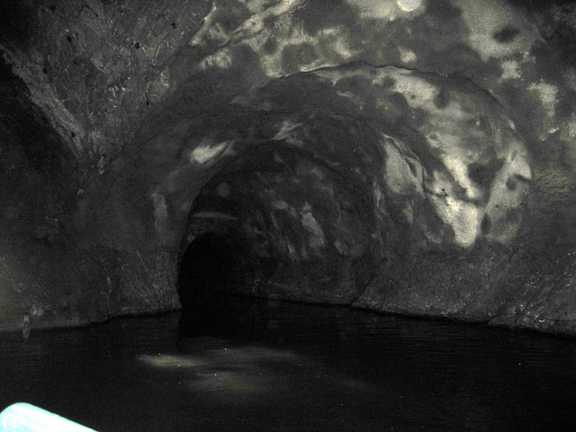
Image: © Rudi Winter Taken: 8 Jun 2014
The Dudley tunnel on the Dudley canal runs through Hurst cavern, a former limestone mine. There is some daylight in the cavern (note reflection in the water) due to a small opening at the top of the cavern known as The Well. It is not clear whether this is due to a roof collapse during mining operations or whether the hole has been built on purpose. Hurst cavern was the last part of the limestone mines in Castle Hill to close, in 1920. The main canal tunnel can be seen here emerging from the limestone. The boat from which this photo was taken belongs to the Dudley Canal Trust and emerges from a side tunnel which was built in 1984 to reconnect Singing Cavern with the main canal tunnel after the original connection a little to the north had collapsed. Castle Hill and nearby Wren's Nest are anticlines of Silurian limestone layers protruding from the surrounding Carboniferous coal beds. Both the limestone and the coal were quarried from the beginning of the industrial revolution and used in the iron smelting industry of the West Midlands of England. Mining finally ceased in 1920. The Dudley canal was completed in 1791, running in a tunnel under Castle Hill for nearly 3km in a SSW direction. Several branch canals were built around the same time to access the limestone seams in the Castle Hill anticline, which run roughly SSE. In addition, there is a westerly branch leading to Wren's Nest. Multiple caverns have been excavated inside Castle Hill, some of which up to 800m in length. Many of the caverns have had roof collapses and rock falls and have since been backfilled. However, some are still accessible by boat through the original tunnels and a few new link tunnels built in the 1980s to enable the Dudley Canal Trust to run circular tours for visitors to see the mines. A schematic map of the canal system is shown on the Trust's website https://web.archive.org/web/20150101180643/http://www.dudleytunnel.co.uk/mines.html (archive link).
Images are licensed for reuse under creativecommons.org/licenses/by-sa/2.0
Image Location
Latitude
52.52036
Longitude
-2.083519