Tin chapel in Trebanog
Introduction
The photograph on this page of Tin chapel in Trebanog by Jaggery as part of the Geograph project.
The Geograph project started in 2005 with the aim of publishing, organising and preserving representative images for every square kilometre of Great Britain, Ireland and the Isle of Man.

There are currently over 7.5m images from over 14,400 individuals and you can help contribute to the project by visiting https://www.geograph.org.uk
Tin chapel in Trebanog
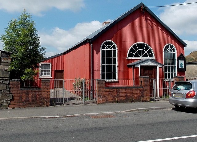
Image: © Jaggery Taken: 30 Jul 2014
Viewed across the A4233 Trebanog Road. Corrugated metal places of worship are sometimes referred to as tin chapels, though this one is corrugated iron. Many similar chapels have been replaced, but this 1881 example has survived into 2014 (viewed in late July). The name board shows Carmel English Congregational Church. The 'English' part of the name states the language of worship, to distinguish the church from those where Welsh is (or was) used. The bottom line of the nameboard shows REMEMBERING MOUNT ZION ENGLISH BAPTIST CHURCH 1923-2009. Mount Zion was a similar tin chapel further south along Trebanog Road. It appears in a Google Earth Street View taken in June 2011, but had been demolished and replaced by a house http://www.geograph.org.uk/photo/4098908 at the late July 2014 date of this view.
Images are licensed for reuse under creativecommons.org/licenses/by-sa/2.0
Image Location
Latitude
51.599495
Longitude
-3.422234