Cat Craig
Introduction
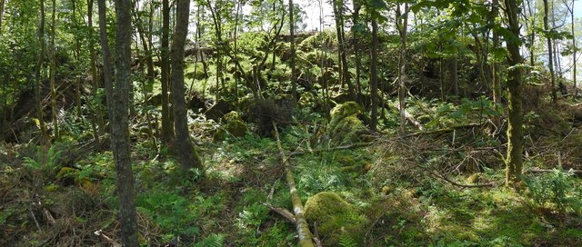
The photograph on this page of Cat Craig by Lairich Rig as part of the Geograph project.
The Geograph project started in 2005 with the aim of publishing, organising and preserving representative images for every square kilometre of Great Britain, Ireland and the Isle of Man.
There are currently over 7.5m images from over 14,400 individuals and you can help contribute to the project by visiting https://www.geograph.org.uk

Image: © Lairich Rig Taken: 20 Jun 2014
This crag, in the Squirrel Wood, is a basaltic formation, one of several in this area (the most impressive of them is the Image; see also Image and Image). Cat Craig is named on large-scale OS mapping, and is visible from the public footpath that leads through the woods, but it is rather overgrown, and obscured by trees. In his book "The Parish of Strathblane" (1886), J G Smith mentions this crag by name, linking it to a battle that occurred in 750 (and which is often called the Battle of Mugdock) between the Picts and the Britons. He explains "Cat Craig" as meaning "Battle Rock", and he links various other place-names nearby with events in the same battle (I quote that passage below). My own view is that it is highly unlikely that such a detailed account of the ancient battle has come down to us in tradition; mainly for that reason, I consider it much more likely that Cat Craig simply means "crag of the cat" (probably the wildcat, Gael. "cat fiadhaich"). On a similar theme, there is a Image nearby, whose name probably means "crag of the badger". [Readers interested in a modern assessment of the sources related to the Battle of Mugdock may wish to look at https://senchus.wordpress.com/2015/02/11/the-battle-of-mugdock-ad-750/ (Senchus site at Wordpress).] Other places Smith mentions in his account of the Battle of Mugdock include the Image; Image, which certainly pre-date the battle of 750 by very many centuries; "Blair's Hill", which is at Image; and "Alreoch", which is at Image Smith gives explanations for these place-names that seem to tie in well with the traditions, but which do not stand up to modern scrutiny (I point this out because they are still sometimes quoted: see Image). While his description of the battle and his place-name etymologies are unsound, they do at least serve as an interesting record of the prevailing beliefs of the time. The relevant passage, which I cite only for its curiosity value, is as follows: "The field of this battle can be traced with but little difficulty. The Cymric army was posted on the high ground on Craigallian – then part of Mugdock – above and to the east and west of the Pillar Craig, with outposts stationed on the lower plateau to the north, and there awaited the Picts, who came up Strathblane valley through Killearn from the north on their way to the interior of Cumbria. Near the top of the Cult Brae, in a line with the Pillar Craig, there is a rock still called Catcraig, i.e., Cadcraig, meaning the "Battle Rock," and in their efforts to dislodge the Cymric army, whom they could not leave in their rear to fall upon them when they had passed, the Picts doubtless had penetrated thus far and here the battle began. It was continued all over Blair or Blairs Hill, i.e., the "Hill of Battle" – the rising ground on Carbeth Guthrie which commands the valley of the Blane – and Allereoch or Alreoch, i.e., the "King's Rock," was certainly so named from being the place where King Talargan fell when the defeated Picts were being driven back to the north-west. The standing stones to the south-east of Dungoyach probably mark the burial place of Cymric or Pictish warriors who fell in the bloody battle of Mugdock." [J G Smith, "The Parish of Strathblane" (1886), page 8].

