Northampton South: aerial 2014
Introduction
The photograph on this page of Northampton South: aerial 2014 by Chris as part of the Geograph project.
The Geograph project started in 2005 with the aim of publishing, organising and preserving representative images for every square kilometre of Great Britain, Ireland and the Isle of Man.

There are currently over 7.5m images from over 14,400 individuals and you can help contribute to the project by visiting https://www.geograph.org.uk
Northampton South: aerial 2014
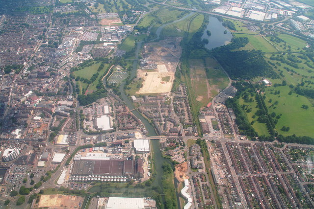
Image: © Chris Taken: 2 Jul 2014
Looking eastwards along the River Nene and South Bridge (Bridge Street), with the Carlsberg Brewery bottom left and Cotton End bottom right. Beckets Park centre left, Delapre Park right. For Thomas Becket connection see: http://www.northamptonshiretimeline.com/scene/1164-thomas-becket/ and Image Immediately right of Beckets Park is a new marina, previously marked "Overflow" on the map. Following on from Beckets Park is Midsummer Meadow, where once stood an outdoor swimming pool, its waters supposedly warmed by the nearby power station - not that you would have noticed. The power station, in Nunn Mills Road (diagonally opposite the marina), was built after World War One and provided all the town’s electricity until 1975. The power station played a key role in World War Two and was a target for Nazi bombers, although it was never hit. One of the turbines in the power station was used to test newly-developed jet engines and their inventor, Sir Frank Whittle, regularly visited the site to monitor progress. When the power station closed in 1979, more than 15,000 people turned out to watch the cooling towers be demolished. The 200ft cooling towers which served the station were demolished in 1979 and further parts of the old power station were knocked down in 2007. The final section, along the waterfront, was set to go at the end of 2013 but some seems to be still there. It is to be the university's Waterside Campus. See: http://www.northamptonchron.co.uk/news/politics/final-remains-of-northampton-s-old-power-station-to-go-1-5715708; http://enterprisezones.communities.gov.uk/university-northampton-granted-permission-develop-waterside-enterprise-zone/ For virtual tour of the old buildings and their graffiti (accompanied by Saint-Saens' "Danse Macabre") see: https://www.youtube.com/watch?v=OmQIxq91DKo
Images are licensed for reuse under creativecommons.org/licenses/by-sa/2.0
Image Location
Latitude
52.233672
Longitude
-0.897361