Start of a path through the Squirrel Wood
Introduction
The photograph on this page of Start of a path through the Squirrel Wood by Lairich Rig as part of the Geograph project.
The Geograph project started in 2005 with the aim of publishing, organising and preserving representative images for every square kilometre of Great Britain, Ireland and the Isle of Man.

There are currently over 7.5m images from over 14,400 individuals and you can help contribute to the project by visiting https://www.geograph.org.uk
Start of a path through the Squirrel Wood
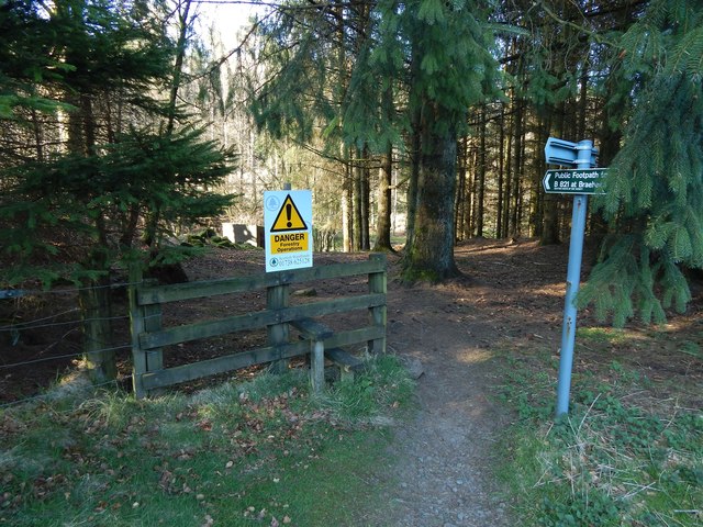
Image: © Lairich Rig Taken: 18 Apr 2014
The area ahead is known as the Squirrel Wood, though that name does not appear on OS maps. The path is signposted as a "Public Footpath to B821 at Braehead". It branches off at this point from the Boards Farm Road, or Gowk Stane Road – http://www.geograph.org.uk/tagged/Gowk+Stane+Road#photo=3997495 – now part of the John Muir Way. See Image for a view of the fence and stile from the other side. For some views from further along the public footpath, see Image, taken about halfway through the woods, and Image and Image, which show the point where it ends, at the B821. Large-scale OS mapping shows that the Squirrel Wood contains several named crags; one of them, the Image, was described by J G Smith as follows: "the south side of the strath has also its rocky cliffs and wooded terraces and fine basaltic columns, particularly at the Pillar Craig on the Craigallian estate" ["Parish of Strathblane" (1886), page 3]. Outcrops I had passed just a few minutes earlier on this walk had much the same appearance: Image and Image Other examples can be found in the Squirrel Wood itself: by far the most impressive is the already-mentioned Image, but it is located some way off the public footpath. Two more modest examples can be seen near the footpath: Image and Image See also Image, from a little further ahead. The writer J G Smith, quoted above, links place-names in this area with events in a battle that took place in 750 (the Battle of Mocetauc / Catohic, often called "the Battle Of Mugdock", though its actual location is uncertain); see Image for more on that topic.
Images are licensed for reuse under creativecommons.org/licenses/by-sa/2.0
Image Location
Latitude
55.984752
Longitude
-4.337133