Park Hill, South Street Park, Sheffield (2)
Introduction
The photograph on this page of Park Hill, South Street Park, Sheffield (2) by Stephen Richards as part of the Geograph project.
The Geograph project started in 2005 with the aim of publishing, organising and preserving representative images for every square kilometre of Great Britain, Ireland and the Isle of Man.

There are currently over 7.5m images from over 14,400 individuals and you can help contribute to the project by visiting https://www.geograph.org.uk
Park Hill, South Street Park, Sheffield (2)
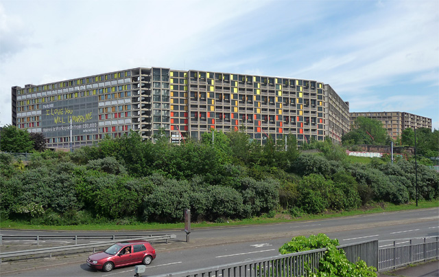
Image: © Stephen Richards Taken: 10 Jun 2012
Park Hill is the only building to put Sheffield on the world map of architecture. Its slabs overlook the city like a C20th fortified wall. It embodies the idea of 'streets in the sky', an attempt to recapture the community spirit of the slums it replaced, its deck access famously wide enough to accommodate a milk float. As well as 994 flats, the estate included a shopping centre, laundry, police station, four pubs, and, later, a primary school with playground. Park Hill was built in 1957-61 and designed by Jack Lynn and Ivor Smith. Grade II* listed. See also: Image] and Image The architecture has taken the rap for the usual neglect and social problems which have since beset the estate. Trendy developers Urban Splash were commissioned to renovate it, including partial privatisation. The obligatory brightly-coloured panels delineate those areas that have been 'splashed'. The bare concrete sections can only watch and await their fate.
Images are licensed for reuse under creativecommons.org/licenses/by-sa/2.0
Image Location
Latitude
53.381236
Longitude
-1.459517