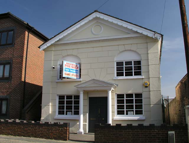
Former Jireh Independent Baptist Chapel
Introduction
The photograph on this page of Former Jireh Independent Baptist Chapel by Andy Potter as part of the Geograph project.
The Geograph project started in 2005 with the aim of publishing, organising and preserving representative images for every square kilometre of Great Britain, Ireland and the Isle of Man.
There are currently over 7.5m images from over 14,400 individuals and you can help contribute to the project by visiting https://www.geograph.org.uk

Image: © Andy Potter Taken: 5 Apr 2007
In Park Terrace East, Horsham. I just took a photograph of this, in passing, as I thought it was a relatively modern office building in the make-it-look-old style so popular these days. On closer inspection it became apparent that it was once a single storey building that had been (unsympathetically) converted to two (or maybe even three) storeys: the stuccoed façade shows a pattern imitating stone blocks but this pattern is not continued in the slab between the upper and lower windows; the reveals of upper windows have an arched top but the windows themselves have a flat top suggesting a lowered ceiling (which hints at a third storey); the steel windows suggest conversion in the mid twentieth century and I'd guess that the porch was added in the late twentieth along with the brick wall at the front. A building with such tall windows suggested a place of worship. The only building used for this purpose, in this location, was the Jireh Independent Baptist Chapel (also known as the Jireh Strict Baptist Chapel). This was confirmed by cross-referencing with Henry Burstow's "Reminiscences of Horsham" http://www.folk-network.com/miscellany/burstow/burstow_6.html which places the chapel within the precincts of the old Horsham gaol. As the gaol was demolished in 1845 and the chapel consecrated in 1857 it seems highly likely that no other structure (or denomination) occupied this site in the interim. I have not determined when the chapel closed but think that the structural alteration would have been undertaken shortly thereafter. (I'll update this if I can find out more.)
Image Location


