Rossendale Valley
Introduction
The photograph on this page of Rossendale Valley by Len Williams as part of the Geograph project.
The Geograph project started in 2005 with the aim of publishing, organising and preserving representative images for every square kilometre of Great Britain, Ireland and the Isle of Man.

There are currently over 7.5m images from over 14,400 individuals and you can help contribute to the project by visiting https://www.geograph.org.uk
Rossendale Valley
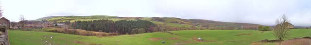
Image: © Len Williams Taken: 11 Jan 2014
This is the view of the Rossendale Valley taken from the Burnley Road. Cribden Hill is the peak on the left of the picture. Refer to picture Image for a view of the valley from a higher location.
Images are licensed for reuse under creativecommons.org/licenses/by-sa/2.0
Image Location
Latitude
53.731452
Longitude
-2.302361