Trongate demolition site
Introduction
The photograph on this page of Trongate demolition site by Thomas Nugent as part of the Geograph project.
The Geograph project started in 2005 with the aim of publishing, organising and preserving representative images for every square kilometre of Great Britain, Ireland and the Isle of Man.

There are currently over 7.5m images from over 14,400 individuals and you can help contribute to the project by visiting https://www.geograph.org.uk
Trongate demolition site
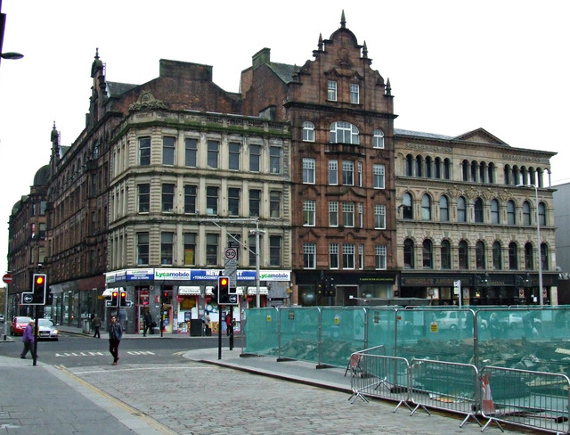
Image: © Thomas Nugent Taken: 5 Nov 2013
Demolition of the old building which stood on the corner has opened up the view of the Britannia Panopticon music hall and other interesting buildings on the south side of Trongate. The building on the left is a Category B Listed http://data.historic-scotland.gov.uk/pls/htmldb/f?p=2200:15:0::::BUILDING:32772 former warehouse at the corner of King Street. The red sandstone building in the centre is also a Category B Listed http://data.historic-scotland.gov.uk/pls/htmldb/f?p=2200:15:0::::BUILDING:32773 former warehouse which was built for the City Improvement Trust. To its right is the Britannia Panopticon music hall, which is the oldest surviving music hall in the world and is Category A Listed http://data.historic-scotland.gov.uk/pls/htmldb/f?p=2200:15:0::::BUILDING:32774 . Stan Laurel made his debut there as a teenager. See also Image & Image
Images are licensed for reuse under creativecommons.org/licenses/by-sa/2.0
Image Location
Latitude
55.857013
Longitude
-4.246842