
Arkleston
Introduction
The photograph on this page of Arkleston by Lairich Rig as part of the Geograph project.
The Geograph project started in 2005 with the aim of publishing, organising and preserving representative images for every square kilometre of Great Britain, Ireland and the Isle of Man.

There are currently over 7.5m images from over 14,400 individuals and you can help contribute to the project by visiting https://www.geograph.org.uk
Arkleston
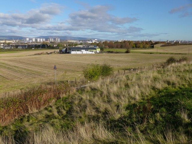
Image: © Lairich Rig Taken: 4 Nov 2013
The 1:50000 OS map simply calls the area Arkleston, while the 1:25000 map names the individual farms. The one that is prominent in this view is Image, with the town of Renfrew visible behind it. Behind and to the right of that farm, the wooded area that is enclosed by a wall is Image: http://www.geograph.org.uk/snippet/10005 The high ground to the right of the cemetery is in the vicinity of Image For another nearby farm, see Image See Image for a wide view, including North and South Arkleston. John Ainslie's 1796 map of the County of Renfrew shows four related farms: High (later South) Arkleston, Laigh (later North) Arkleston, East Arkleston (now ruined – see above), and West Arkleston. The last of these is not to be found on modern maps. However, it appears to correspond to what came to be called Arkleston House, which old OS maps show standing on the site that Ainslie labelled West Arkleston. Arkleston House is now gone, but it was formerly depicted on OS mapping at about Image; the area in which the house stood is shown in Image and Image The particular spot from which the present picture was taken is located in a Image, at a point which the second-edition OS map (revised c.1895) labels an "old quarry"; at that time, the pit was filled with water. It is not marked on OS maps after the Second World War, and the land there is now level, with very little evidence of the former quarry now visible on the ground. For a view of the site, and for further information, see Image Immediately next to that quarry there used to be a powder magazine. The building is depicted on the first-edition OS map (c.1857), but it was cleared away before the Second World War. It stored powder for merchants, but it was operated by the Paisley Police Commissioners: see Image for its location, and for further comments. A little further to the west, there used to be some reservoirs, a couple of older quarries, and the Arkleston Print Works. For a view of that area, and for more comments on each of those sites, see Image Any trace of the quarries is long gone, but they are thought to have provided the limestone from which the nearby powder magazine was built. - - • - - The area shown here has long been known as Arkleston. For example, a document dating from 1265 mentions "a carucate (or ploughgate) of land, formerly held by Grimketil, which is now called Arkleston": "et carucatam terre ... quam quondam Grimketil tenuit que nunc dicitur Arkylliston". A document from 1495 cites the bailies and community of Paisley for several misdeeds, including the violent tearing down of a house lying in the toun (a ferm toun, not a "town" in the modern sense) of Arkleston: "the maistyrfull douncasting of ane howss pertenyng to the saidis Abbot and convent liant in the thoun of Arkilstoun within the said barony of Renfrew". A 1587 charter in favour of Lord Claud Hamilton mentions "Arkleston and wood of the same": "Arklstoun et siluam earundem". The area is evidently named after a certain Arkyll or Arkill, but it is not clear who he was. Grimketil, who once held these lands (as mentioned in the document of 1265), has a Norse name. - - • - - References: The texts of the early documents mentioned above are given in "Charters and Documents Relating to the Burgh of Paisley (1163-1665) and Extracts From the Records of Town Council (1594-1620)", edited, with an introduction, by W M Metcalfe (Paisley, Alexander Gardner, 1902). ▪ The 1265 document is a "Transumpt by Pope Clement IV of all the Churches, Lands and other Privileges belonging to the Monastery of Paisley" (Rome, 1265). ▪ The 1495 document is a "Citation of the bailyes and comunite of Renfrew for the custumys in the thown of Paslay wrangusly thayn" (Perth, 2nd December, 1495). That is, "for customs (impost or duty) unlawfully taken in the town of Paisley". ▪ The 1587 document is a "Charter of Lord Claud Hamilton" (Edinburgh, 29th July, 1587). It is by King James, in favour of Hamilton. Metcalfe gives the charter in the original Latin, and then in translation.
Images are licensed for reuse under creativecommons.org/licenses/by-sa/2.0
Image Location

Latitude
55.860732
Longitude
-4.392802