Grid references of previous Ordnance Survey HQ locations
Introduction
The photograph on this page of Grid references of previous Ordnance Survey HQ locations by John Lucas as part of the Geograph project.
The Geograph project started in 2005 with the aim of publishing, organising and preserving representative images for every square kilometre of Great Britain, Ireland and the Isle of Man.

There are currently over 7.5m images from over 14,400 individuals and you can help contribute to the project by visiting https://www.geograph.org.uk
Grid references of previous Ordnance Survey HQ locations
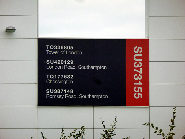
Image: © John Lucas Taken: 7 Oct 2013
A large plaque on the new OS HQ showing the grid references of previous main OS locations (and that of the current building). The OS was established at the Tower of London in 1716. After a fire at the Tower in 1841 it moved to London Road, Southampton. Almost exactly 100 years later, wartime bombing of London Road resulted in the HQ being moved to Chessington and a considerable amount of production, particularly that of small and medium scales mapping, was moved to temporary buildings at Crabwood beside Romsey Road, Southampton. Large scale map production remained at the London Road site. The new production and HQ buildings at Maybush were opened in 1969 (by The Queen - I was there!), the sites at Crabwood, London Road and Chessington then being released, and so HQ and production were again centralised at the one site. With rationalisation and the adoption of digital production methods, the size of the Maybush complex was far greater than needed, and so another move took the OS to the current building at Adanac Park, the move being completed in 2011. The main building at Maybush has now been demolished in preparation for house building but the separate HQ building was 'hived off' in 1999 and remains in use as offices. See also Image and Image
Images are licensed for reuse under creativecommons.org/licenses/by-sa/2.0
Image Location
Latitude
50.937731
Longitude
-1.467681