Weedon Depot
Introduction
The photograph on this page of Weedon Depot by Chris Lowe as part of the Geograph project.
The Geograph project started in 2005 with the aim of publishing, organising and preserving representative images for every square kilometre of Great Britain, Ireland and the Isle of Man.

There are currently over 7.5m images from over 14,400 individuals and you can help contribute to the project by visiting https://www.geograph.org.uk
Weedon Depot
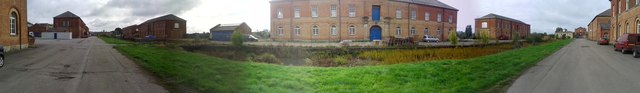
Image: © Chris Lowe Taken: 5 Oct 2013
Former Ordnance Depot at Weedon Bec. The extensive barracks were begun in 1803 during the Napoleonic wars, but most of the buildings (including 12 powder magazines) have been demolished. This is a 180-degree panoramic shot and therefore the straight road appears as two roads. In fact it is parallel to the grass verge and canal in the foreground.
Images are licensed for reuse under creativecommons.org/licenses/by-sa/2.0
Image Location
Latitude
52.230496
Longitude
-1.0831