Vale of Leven Industrial Estate
Introduction
The photograph on this page of Vale of Leven Industrial Estate by Lairich Rig as part of the Geograph project.
The Geograph project started in 2005 with the aim of publishing, organising and preserving representative images for every square kilometre of Great Britain, Ireland and the Isle of Man.

There are currently over 7.5m images from over 14,400 individuals and you can help contribute to the project by visiting https://www.geograph.org.uk
Vale of Leven Industrial Estate
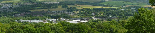
Image: © Lairich Rig Taken: 9 Aug 2013
Other than from the air, this is probably the best place from which to get a view of the whole estate. See http://www.geograph.org.uk/tagged/place:Vale+of+Leven+Industrial+Estate for related images. In the left-hand half of the image, the arc of housing immediately behind the industrial estate is the Strathleven Housing Estate. Behind that, further up the hill, is the Beechwood and Wheatcroft Estate, extending out like an arm from Braehead and Redburn, part of which can be seen at the far left. A little right of centre, Image can be seen standing alone. Two outlying buildings on the right are a Image (with Image visible behind it) and a Image
Images are licensed for reuse under creativecommons.org/licenses/by-sa/2.0
Image Location
Latitude
55.970352
Longitude
-4.576985