A465 improvements, Nantybwch roundabout (4)
Introduction
The photograph on this page of A465 improvements, Nantybwch roundabout (4) by Robin Drayton as part of the Geograph project.
The Geograph project started in 2005 with the aim of publishing, organising and preserving representative images for every square kilometre of Great Britain, Ireland and the Isle of Man.

There are currently over 7.5m images from over 14,400 individuals and you can help contribute to the project by visiting https://www.geograph.org.uk
A465 improvements, Nantybwch roundabout (4)
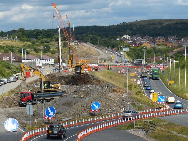
Image: © Robin Drayton Taken: 30 Jul 2013
Looking eastward along the A465 Heads of the Valleys Road as it approaches the Tredegar turnoff. Behind the viewpoint is the section of the road from Dowlais Top to Tredegar that was dualled from 2002-4 http://www.geograph.org.uk/photo/3252820 . In anticipation of the continued dualling beyond Tredegar, slip roads were constructed to a roundabout and a huge ridge of earth was left to take the future dual carriageway over the roundabout. This plan was subsequently changed to take the road under the roundabout. Work on this has now started and this photo shows work in progress to remove the ridge of earth. See http://www.geograph.org.uk/photo/3161528 for a picture before this work was started.
Images are licensed for reuse under creativecommons.org/licenses/by-sa/2.0
Image Location
Latitude
51.787331
Longitude
-3.265174