Metrolink, Droylsden
Introduction
The photograph on this page of Metrolink, Droylsden by David Dixon as part of the Geograph project.
The Geograph project started in 2005 with the aim of publishing, organising and preserving representative images for every square kilometre of Great Britain, Ireland and the Isle of Man.

There are currently over 7.5m images from over 14,400 individuals and you can help contribute to the project by visiting https://www.geograph.org.uk
Metrolink, Droylsden
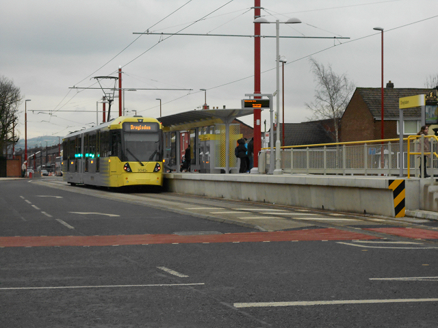
Image: © David Dixon Taken: 9 Feb 2013
Metrolink Bombardier M5000 tram 3045 stands at Droylsden Tram Station having arrived from Manchester. Although the line from Piccadilly to Droylsden wasn't officially opened until 11th February, this tram was operating as part of a free service as a "thank-you" to residents living next to the route (http://www.manchesterconfidential.co.uk/News/Droylsden-Metrolink-Route-Opening-Imminent Manchester Confidential). The new Droylsden Tram stop on Ashton Road, just to the east of Market Street, will operate as the temporary terminus for the Metrolink East Manchester Line Extension; a facing connection allows trams from the outbound platform to move forward and onto the inbound line to reverse and return towards Manchester. The East Manchester line will eventually run to Ashton-Under-Lyne. http://www.lrta.org/Manchester/ashton.html LRT Association "Metrolink - Manchester to Droylsden and Ashton-Under-Lyne" http://www.metrolink.co.uk/futuremetrolink/Pages/east-manchester-line.aspx Transport for Greater Manchester - Metrolink East Manchester Line
Images are licensed for reuse under creativecommons.org/licenses/by-sa/2.0
Image Location
Latitude
53.479356
Longitude
-2.145064