Building at Westport (former Timber store)
Introduction
The photograph on this page of Building at Westport (former Timber store) by Nigel Mykura as part of the Geograph project.
The Geograph project started in 2005 with the aim of publishing, organising and preserving representative images for every square kilometre of Great Britain, Ireland and the Isle of Man.

There are currently over 7.5m images from over 14,400 individuals and you can help contribute to the project by visiting https://www.geograph.org.uk
Building at Westport (former Timber store)
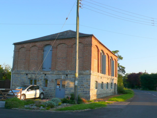
Image: © Nigel Mykura Taken: 22 Jul 2012
This large brick and stone building was once a wood and timber storage building connected with the Westport Canal. It has been very well renovated and now appears to be a residence. It is Grade II listed and its listing is as follows:- ST31NE BARRINGTON CP WESTPORT 5/140 Timber store at former canal basin, now in grounds of Laurel Cottage 28.10.87 GV II Timber store. Circa 1836. Coursed and squared lias plinth, projecting lias band at first floor level, brick to first floor; consisting of 5 tall openings to each face, imposts, segmental heads, one archway open with paired blank doors and strap hinges, brick dentil eaves cornice, high pyamidal slate roof. Square on plan, ground floor used as stabling for barge horses, upper floor for drying timber, formerly open archways, to allow freeflow of air through the building. Ground floor of roadside with 4 small segmental-headed window openings, 3 blocked, one with a 2-light casement, glazing missing, to right segmental head door opening with plank doors. C20 lean-to outshuts are not of special interest. Part of an important complex of structures forming a canal basin. Presently used for light industry. Part of former Westport Canal.
Images are licensed for reuse under creativecommons.org/licenses/by-sa/2.0
Image Location
Latitude
50.974215
Longitude
-2.878457