The Scott family burial ground
Introduction
The photograph on this page of The Scott family burial ground by Lairich Rig as part of the Geograph project.
The Geograph project started in 2005 with the aim of publishing, organising and preserving representative images for every square kilometre of Great Britain, Ireland and the Isle of Man.

There are currently over 7.5m images from over 14,400 individuals and you can help contribute to the project by visiting https://www.geograph.org.uk
The Scott family burial ground
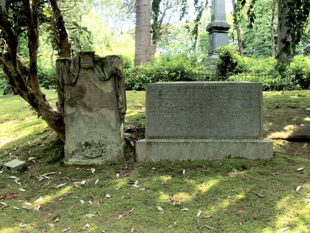
Image: © Lairich Rig Taken: 18 Jun 2012
One of Greenock's pre-eminent shipbuilding families is commemorated here. On the stone on the right, the first person named is John Scott, shipbuilder in Finnart, Greenock, 25th April 1786 – 8th January 1874. However, the family's business was established even earlier, when another John Scott established his shipyard in 1711. From "Two Centuries of Shipbuilding by the Scotts at Greenock" (2nd edn, 1920): "Scotts' firm was founded in 1711 by John Scott primus, who built herring busses and smaller boats. Records of the early times were in existence up to the beginning of the nineteenth century, when they were destroyed by fire, and with them much invaluable information regarding the industrial and shipping history of the town. The work of the Scotts for the greater part of the first hundred years was almost entirely confined to fishing and coasting vessels, their original yard at the mouth of the West Burn, on ground leased from Sir John Schaw. Previous to this the industry had been carried on intermittently. It was then placed on a stable basis." "A development in the size of ships began in 1752 with the opening of the Greenland whale fisheries. William Scott, son of John, who succeeded to the business and with his brother James greatly extended the works, built in 1765 a large square-rigged ship for Hull owners, of timber from the Ducal woods at Hamilton. In 1776 the number of vessels built at Greenock, ranging up to 77 tons, was eighteen, of 1,073 tons aggregate, and of these six were from this yard. The Brunswick, 600 tons (1,000 tons carrying capacity), in 1791, for the Nova Scotia trade, and the Caledonia, 650 tons, in 179, both by the Scotts and each in its year the largest ship in Scotland, signalised the start of a period of greater activity, especially in respect of large ocean ships. Some years before, in 1767, this firm had feued ground on the shore east of the West Burn and built a graving dock, on the floor of which the inaugural dinner was held." "John Scott secundus, son of William, who died in 1769, followed in his father's footsteps, while his brother William established an important shipyard at Barnstaple. It is noteworthy that William was the father of James M. Scott, who about 1847 founded penny banks in Greenock, and engaged in much other social work. On the departure of William the firm was known as John Scott & Sons. So successful was the management that in three successive years – 1787/8/9(*) large plots of ground were purchased from Lord Cathcart for extensions, which at that time almost wholly occupied the foreshore from the West Quay to the West Burn." [(*) The year of the third feu appears to have been 1799 rather than 1789; details of all three may be found on pages 148-149 of George Williamson's "Old Greenock from the earliest times ..." (1886).] Much later, a merger resulted in the formation of Scott Lithgow Ltd. The huge crane – shown in https://canmore.org.uk/site/68379/greenock-belhaven-street-glen-shipyard (at Canmore) – at their Glen Shipyard (Image) was, even when viewed from the other side of the Clyde, an eye-catching structure. It was demolished in 1997; see also Image The Scott burial ground is location № 14 on the Blue Walk in the "Greenock Cemetery Walks" booklet (see the end-note). For related images elsewhere, see Image and Image
Images are licensed for reuse under creativecommons.org/licenses/by-sa/2.0
Image Location


Leaflet Map data © OpenStreetMap
Latitude
55.948393
Longitude
-4.780724