
Site of old ferry crossing on the River Leven
Introduction
The photograph on this page of Site of old ferry crossing on the River Leven by Lairich Rig as part of the Geograph project.
The Geograph project started in 2005 with the aim of publishing, organising and preserving representative images for every square kilometre of Great Britain, Ireland and the Isle of Man.

There are currently over 7.5m images from over 14,400 individuals and you can help contribute to the project by visiting https://www.geograph.org.uk
Site of old ferry crossing on the River Leven
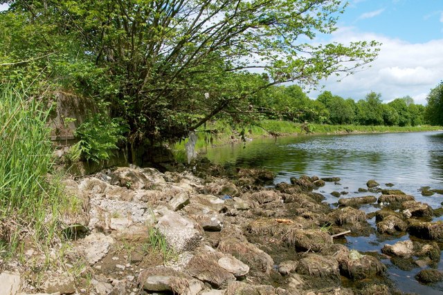
Image: © Lairich Rig Taken: 4 Jun 2012
This is the western side of the River Leven, at the end of a road that is now called Image (it was earlier and more correctly called Turnbull's Loan, pronounced "Trummel's Loan"; see the link just given). The platform on the left was associated with a ferry crossing that is marked on the second-edition OS map (surveyed in 1897), and on the equivalent OS map surveyed in 1914. By the 1930s, the crossing is no longer shown on the map. As the photograph shows, many blocks, associated either with this ferry crossing or with another structure nearby, have ended up in the river at this point. Except from the bed of the river (whose level was unusually low on this occasion, giving a suitable vantage point), the platform is not well seen, because dense vegetation grows on top of it and overhangs the side facing the water. What looks like a similar structure could be seen amongst the bushes on the opposite side of the river. Of another ferry crossing, which is shown on the same old maps as being only a short distance upriver of this one, no trace is now evident, at least on this side of the river (the steps that lead down to the water there are modern). [Of the two men who were conversing on the nearby part of the riverside path at the time, my thanks to the friendly and helpful one, who took the time to point out this structure and the best way to get a good view of it.] See also Image, located considerably further upriver.
Images are licensed for reuse under creativecommons.org/licenses/by-sa/2.0
Image Location

Latitude
55.977811
Longitude
-4.581328