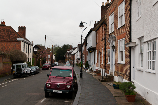
Fishpool Street
Introduction
The photograph on this page of Fishpool Street by Ian Capper as part of the Geograph project.
The Geograph project started in 2005 with the aim of publishing, organising and preserving representative images for every square kilometre of Great Britain, Ireland and the Isle of Man.
There are currently over 7.5m images from over 14,400 individuals and you can help contribute to the project by visiting https://www.geograph.org.uk

Image: © Ian Capper Taken: 3 May 2012
Once the main road from London to the north west, following the diversion of the former Watling Street up Holywell Hill and then down to St Michaels in the 9th or 10th century. Following the building of Verulam Road by Thomas Telford in 1826, it lost this status but still served as the road out towards Hemel Hempstead, and when road numbers were introduced in 1922 it former part of the A414 Hemel Hempstead to Chelmsford road. This role in turn ceased in the 1950s or so following the link from Batchwood Drive to Bluehouse Hill and the transfer of that number to Catherine Street, and Fishpool Street is now a quiet back road. This is the bottom end of the road, as it approaches its junction with St Michael's Street. Most of the houses in this view are grade II listed, with one grade II* listed. In particular Manor Garden House (on the left, with the white front) - 17th century, grade II* listed - see www.historicengland.org.uk/listing/the-list/list-entry/1103113. No 137 (the brick faced house beyond) - late 18th century but with earlier origins, see www.historicengland.org.uk/listing/the-list/list-entry/1347151. On the right: Nos 156 and 158 (white fronted): part of a group of 17th century timber framed buildings - see www.historicengland.org.uk/listing/the-list/list-entry/1103147. No 160 (brick with ornate door): late 18th century front to 17th century building - see www.historicengland.org.uk/listing/the-list/list-entry/1347131. Nos 162 and 164 (brick): 19th century but of earlier origins - see www.historicengland.org.uk/listing/the-list/list-entry/1172909. Nos 166 and 168 (with overhanging first floor): 16th century - see www.historicengland.org.uk/listing/the-list/list-entry/1103148. The next few buildings up to no 174, but not visible here in detail, are grade II listed, with the remainder locally listed, until: In the distance is the Black Lion, an inn dating from around 1700 - see www.historicengland.org.uk/listing/the-list/list-entry/1172914.

