Merkins Farm
Introduction
The photograph on this page of Merkins Farm by Lairich Rig as part of the Geograph project.
The Geograph project started in 2005 with the aim of publishing, organising and preserving representative images for every square kilometre of Great Britain, Ireland and the Isle of Man.

There are currently over 7.5m images from over 14,400 individuals and you can help contribute to the project by visiting https://www.geograph.org.uk
Merkins Farm
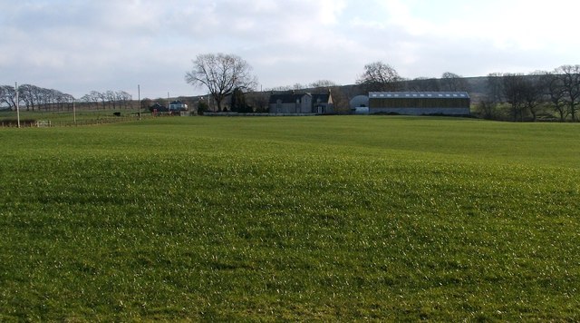
Image: © Lairich Rig Taken: 3 Feb 2012
The photograph was taken from Auchincarroch Road, which is also one of the local core paths (since there is no pavement, walkers should look out for traffic). See also Image At the time of submission of the present photograph, it was primarily sheep farming that was carried on here, and plans for a ten-turbine wind farm had not yet been approved; the wind farm would be centred on the Image; see Image As noted in the first section of a Geograph article – http://www.geograph.org.uk/article/West-Dunbartonshire-Limestone-Industry-Network – the planning application for the wind farm was rejected in October 2013. When the very extensive Strathleven Estate was put up for sale in 1950, "The Grouse Moor of Dumbarton Muir and Merkins Farm" was lot number 9 (the tenant at that time was Mr W J Bennie). The lot amounted to 6261 acres, 1 rood, 38 poles. The grouse moor was described as "well butted", and "was once one of the finest in the country, producing 1000 brace of grouse in good season". Faint remnants of grouse butts can still be seen on the moor, some of them marked on OS maps (see Image and Image), others not (see Image and Image). The Strathleven Estate that was disposed of in 1950 by means of Messrs Jackson-Stops and Staff was owned by the Crum-Ewings, who were formerly known as the Ewings of Strathleven; see Image and Image The farms, though, were let out to tenant farmers. Towards the end of the nineteenth century, the farmer at Merkins was John Corson Anderson (d.1909), formerly of Strachurmore (Image) in Argyllshire; in 1797, the farmer was John Galloway [Farm Horse Tax Rolls]. The Strathleven estate had formerly been called Levenside; at an even earlier period, it formed part of the lands of Kirkmichael-Fleming [for the details, see pages 208-210 of the second volume of Joseph Irving's "The Book of Dumbartonshire" (1879)]. William Cochran, a grandson of the first Earl of Dundonald, had a mansion house built at Levenside: Image After his death, the estate passed into the ownership of the advocate Archibald Campbell, and then to his son John Campbell, who was better known by his judicial title, Lord Stonefield. It was during that family's ownership of Levenside that Merkins was added to the estate. In the 1830s, the Glasgow merchant James Ewing bought the estate from Lord Stonefield's grandson. Ewing changed the name of the mansion house and estate to Strathleven. As noted above, the Strathleven estate was finally sold off as lots in 1950. - - • - - The name Merkins is probably connected with "the ferkins and merkins" mentioned in a 1609 charter of James VI, although this sheds no light on the meaning of the name; the charter sets out the boundaries of Dumbarton's Common Muir with reference to local place-names, the relevant part being as follows: "... and therefrae to the common furds, and therefrae to the common cairn called the Lang Cairn, and therefrae westward to the Red brae, upon the lands and merches of the ferkins and merkins, and therefrae to the north-west part of the hill where the Standand Stanes are fixt; and therefrae westward to the auld monument of stone called the Common Kist" [Joseph Irving, "The History of Dumbartonshire" (1860), page 179]. [In J.G.Smith's "Strathendrick and its Inhabitants from Early Times" (1896), the transcription of this part of the charter is slightly different (see Image), and the reading given there is "Forkins and Merkins". Yet another source refers instead to the "Jerkins and Merkins".] The present-day Red Brae is adjacent to Merkins Muir, suggesting that the latter does indeed correspond to the "ferkins and merkins" of the charter. All of the other places mentioned in that section of the charter are still identifiable: Image, Image, Red Brae (Image), the Image, and Image (that last item also explains where all the stones went that formerly covered the Common Kist). The Pont/Blaeu map of the Lennox (published in 1654, but based on surveys in the 1580-90s) shows "Merknisk" near the Burn of Mewy (probably the Finland Burn; see Image). Roy's Military Survey of Scotland (1740s-50s) does not include the farm by name, but his map does not always show or name all of the farms in a given area. Charter #2038, dated 17th July 1629, in the "Calendar of the Laing Charters", twice refers to the farm as "Merkinche". One of the occurrences is in the list of witnesses to the charter; these include "Donald McLintok in Merkinche, and John, his son". This form of the name is similar to that of Markinch (Image) – Scots "Merkinch" – in Fife, possibly from the Gaelic for "Horse Meadow". I mention this only by way of interest: I should stress that I do not know whether the place-name Merkins has a similar origin; only one attested spelling of the name bears any real resemblance to Markinch, and even that similarity may be nothing more than coincidence. In the same spirit, perhaps (again, this is my own observation) the "Ferkins" mentioned in the 1609 charter is to be identified with "the forty-shilling lands of Ferkinch", one of the lands with which Dumbarton's Collegiate Church was said to be endowed (see page 69 of John Glen's 1847 "History of the Town and Castle of Dumbarton").
Images are licensed for reuse under creativecommons.org/licenses/by-sa/2.0
Image Location
Latitude
56.012939
Longitude
-4.503609