The former Burton's building
Introduction
The photograph on this page of The former Burton's building by Lairich Rig as part of the Geograph project.
The Geograph project started in 2005 with the aim of publishing, organising and preserving representative images for every square kilometre of Great Britain, Ireland and the Isle of Man.

There are currently over 7.5m images from over 14,400 individuals and you can help contribute to the project by visiting https://www.geograph.org.uk
The former Burton's building
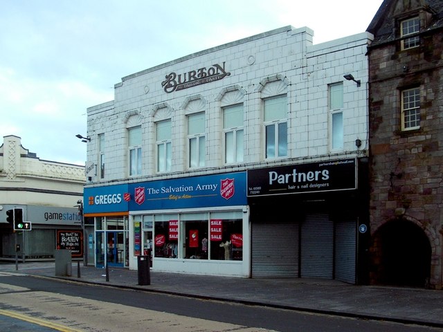
Image: © Lairich Rig Taken: 1 Jan 2012
This building stands on Dumbarton's High Street, at the corner (visible at the left) of Quay Street. The building immediately to the right is Image, and the arched opening leads to Image (The street is not usually so deserted; the picture was taken on New Year's Day.) The name Burton is prominent in this view, but the text reads, in full, "Montague Burton – the Tailor of Taste". The dark opening on the right is that of Image, a covered passageway leading through the adjacent Image A blue plaque (for the former Burton's building) can be seen just to the left of the opening of the pend; directly below that plaque, but too small and dark to be visible in the present view, is a foundation stone: Image Another foundation stone is on Quay Street (the lane whose entrance can be seen on the left): Image The former Burton's building dates from about 1938, but it was built upon the site of a historic building, the Elephant Hotel (not to be confused with the Image, which is located at the eastern end of the High Street). The Elephant Hotel was originally called the Town's Arms Inn, and it was built by the same John Brown (Image) who was responsible for building Image Work on the building began in 1760 (five years before the bridge was built); it opened for business in 1762. For a detailed history, see "The Elephant Hotel" (2008) by Michael C. Taylor; it suffices to note here that it was demolished in 1935, and that it had been built on the site of a still earlier building, which had been owned by Robert Harris, a doctor, and which was referred to in the council's minutes as Harris's Wastage. Across the road from the Elephant Inn and Glencairn's Greit House, in (roughly) the area where the entrance to the Image is now located (Image), there would once have stood the town's Tolbooth, with the Mackenzie House standing immediately next to it (on the east); for those buildings, see Image At a later date, Heggie's Buildings occupied much the same area: specifically, what is now the covered entrance shown in Image, and the area just to its left (where there is now a pharmacy).
Images are licensed for reuse under creativecommons.org/licenses/by-sa/2.0
Image Location
Latitude
55.943149
Longitude
-4.571173