Holywell Hill
Introduction
The photograph on this page of Holywell Hill by Ian Capper as part of the Geograph project.
The Geograph project started in 2005 with the aim of publishing, organising and preserving representative images for every square kilometre of Great Britain, Ireland and the Isle of Man.

There are currently over 7.5m images from over 14,400 individuals and you can help contribute to the project by visiting https://www.geograph.org.uk
Holywell Hill
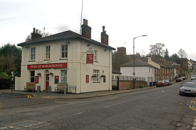
Image: © Ian Capper Taken: 4 Dec 2011
Looking up Holywell Hill, with the Duke of Marlborough pub on the left. All the buildings here date from the mid 19th century, with the row of cottages beyond being named Spencer Place in late 19th century maps. Near here, to the right of the present road at a point opposite the top end of the row of cottages, once stood Holywell House, a Tudor mansion the extension of whose gardens in the late 17th century led to the diversion of the original straight route of Holywell Hill to the west, to follow the route of what is now Grove Road, the start of which can be seen in front of the pub and the end of which is beyond the cottages. From 1684, the house was owned by John Churchill, later first Duke of Marlborough, who had come into its ownership following his marriage to Sarah Jennings. The Duke died in 1722, leaving Sarah as sole owner, who then in 1744 passed it to her grandson, John Spencer, who in turn passed it to his son, another John, who later became the first Earl Spencer of Althorp (from whom Lady Diana Spencer was descended). The family stopped using the house in the early 19th century (although retaining ownership of various lands in and around St Albans, with road names such as Jennings Road, Althorp Road, Marlborough Road and Spencer Mews maintaining the connection). The house was demolished in 1837, and this enabled the corporation of St Albans to reinstate the direct route up Holywell Hill, as seen here. The name of the pub and the former name of the cottages both commemorate the former owners of the estate. Both the pub and the cottages are locally listed. In the background is can be seen the tower of St Albans Abbey.
Images are licensed for reuse under creativecommons.org/licenses/by-sa/2.0
Image Location


Leaflet Map data © OpenStreetMap
Latitude
51.747109
Longitude
-0.342163