Motte & Bailey Castle, Elsdon
Introduction
The photograph on this page of Motte & Bailey Castle, Elsdon by Andrew Curtis as part of the Geograph project.
The Geograph project started in 2005 with the aim of publishing, organising and preserving representative images for every square kilometre of Great Britain, Ireland and the Isle of Man.

There are currently over 7.5m images from over 14,400 individuals and you can help contribute to the project by visiting https://www.geograph.org.uk
Motte & Bailey Castle, Elsdon
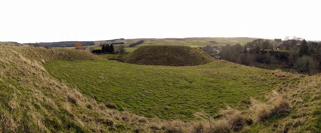
Image: © Andrew Curtis Taken: 9 Dec 2011
Mote Hills is probably the best preserved medieval earthwork castle in Northumberland. It was built by Robert de Umfraville, a relative of William the Conqueror not long after the Norman Conquest and stands on a natural spur of a hill. The mound is 15m high and 80m in diameter across the base, and 46m across the top. The motte is surrounded by a strong rampart on the north and east sides, while the west side is protected by steep natural defences dropping to the Elsdon Burn. The bailey lies to the north of the motte and is separated from it by a ditch, some 15m wide. The bailey is almost rectangular and measures 72m long by 48m wide and is strongly defended on all sides by a massive earthen rampart. There is a shallow ditch around the whole castle. It is thought that the Elsdon castle was the predecessor of the family seat at Harbottle http://www.keystothepast.info/article/10339/Site-Details?PRN=N9744 http://www.pastscape.org.uk/hob.aspx?hob_id=19720
Images are licensed for reuse under creativecommons.org/licenses/by-sa/2.0
Image Location


Leaflet Map data © OpenStreetMap
Latitude
55.235396
Longitude
-2.099664