The Shard from Guy Street Park
Introduction
The photograph on this page of The Shard from Guy Street Park by Marathon as part of the Geograph project.
The Geograph project started in 2005 with the aim of publishing, organising and preserving representative images for every square kilometre of Great Britain, Ireland and the Isle of Man.

There are currently over 7.5m images from over 14,400 individuals and you can help contribute to the project by visiting https://www.geograph.org.uk
The Shard from Guy Street Park
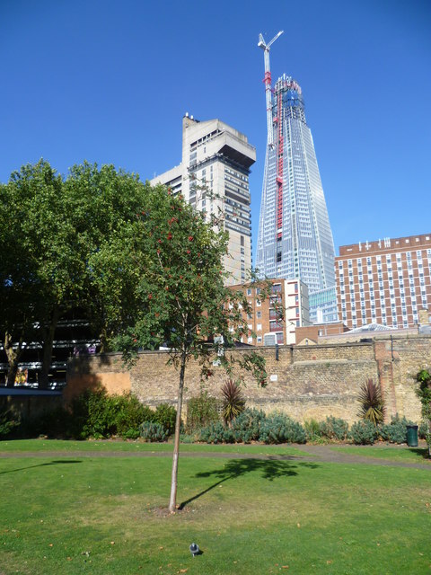
Image: © Marathon Taken: 14 Oct 2011
Originally open fields, the land on which most of Guy Street Park stands belonged to Guy's Hospital in the 18th century. It was used as a burial ground until it was closed and leased to a builder. By the end of the 19th century, Bermondsey Vestry needed a public recreation ground for its inhabitants who were living in very overcrowded conditions. The land was purchased with the help of the London County Council and others. It was opened on March 30th 1899 and called Nelson Recreation Ground. Despite War damage, the park was refurbished and extended. By the 1990s it had become very run down and local people formed the Friends of Guy Street Park. The new Guy Street Park opened in April 2003. This view shows how close the park is to Guy's Hospital. Guy's Tower is to the left above the tree whilst the two lower blocks are staff accommodation. Rising above everything else is The Shard which was nearing completion when the photograph was taken. This will be the tallest building in the European Union at 1,017 feet. Above it is Europe's highest crane and a number of newspaper articles have featured what it is like to be in the cab of the crane.
Images are licensed for reuse under creativecommons.org/licenses/by-sa/2.0
Image Location
Latitude
51.501605
Longitude
-0.086379